11.1              introduction

11.1.1         Background

This Section presents the possible landscape and visual impacts of the proposed public housing development and recommends mitigation measures to alleviate the potential impacts that may arise from the proposed development.  It includes the description of existing landscape resources (LRs) and landscape character areas (LCAs) within 500m assessment area offset from the Project Development Area (PDA) boundary, and visual sensitive receivers (VSRs) within the visual envelope; the impacts associated with the construction and operation of the proposed public housing development as well as the enhancement and mitigation measures.

11.2              ENVIRONMENTAL LEGISLATION, STANDARDS AND GUIDELINES

11.2.1          The following or the latest legislation, standards, circulars and guidelines are applicable to landscape and visual impact assessment associated with the construction and operation of the proposed public housing development:


      Environmental Impact Assessment Ordinance Guidance Note 8/2010 – Preparation of Landscape and Visual Impact Assessment;

      Environment Impact Assessment Ordinance (Cap. 499. S16) and EIAO-TM Annexes 3,10,11,18 & 20;

      EIA Study Brief No. ESB-318/2019;

      Town Planning Board Guideline No. 41 – Guidelines on submissions of Visual Impact Assessment for Planning Applications to the Town Planning Board;

      Town Planning Ordinance (Cap 131);

      Town Planning (Amendment) Ordinance, 2004;

      Hong Kong Planning Standards and Guidelines Chapters 4, 10, 11 and 12;

      Forests and Countryside Ordinance (Cap. 96);

      Protection of Endangered Species of Animals and Plants Ordinance (Cap. 586);

      AFCD Nature Conservation Practice Note No. 2 – Measurement of Diameter at Breast Height (DBH);

      AFCD Nature Conservation Practice Note No. 3 – The Use of Plant Names;

      Agriculture, Fisheries & Conservation Department Publication - 'Rare and Precious Plants of Hong Kong' (2003);

      Agriculture, Fisheries & Conservation Department Publication - 'Check List of Hong Kong Plants' (2012);

      CEDD TC No. 5/2018 – Vetting Committee on Slope Appearance;

      CEDD TC No. 12/2019 – Guidelines for Making Submissions to the Advisory Committee on the Appearance of Bridges and Associated Structures;

      CEDD TC No. 7/2020 – Tree Works Vetting Panels;

      CEDD – Greenery Master Plan;

      DEVB TC(W) No. 2/2012 – Allocation of Space for Quality Greening on Roads;

      DEVB TC(W) No. 3/2012 – Site Coverage of Greenery for Government Building Projects;

      DEVB TC(W) No. 2/2015 – Green Government Buildings;

      DEVB TC(W) No. 6/2015 – Maintenance of Vegetation and Hard Landscape Features;

      DEVB TC(W) No. 5/2017 – Community Involvement in Planting Works;

      DEVB TC(W) No. 1/2019 – Railway Protection;

      DEVB TC(W) No. 4/2020 – Tree Preservation;

      DEVB TC(W) No. 5/2020 – Registration and Preservation of Old and Valuable Trees;

      DEVB TC(W) No. 9/2020 – Blue-Green Drainage Infrastructure;

      DEVB – Guiding Principles on Use of Native Plant Species in Public Works Projects;

      DEVB – Guidelines on Tree Transplanting;

      DEVB – Street Tree Selection Guide;

      DEVB – Handbook on Tree Management;

      DEVB, GLTMS – Guidelines on Tree Preservation during Development;

      DEVB, GLTMS – Guidelines for Tree Risk Assessment and Management Arrangement, (9th edition Rev. 1 1st April 2020);

      ETWB TC No. 17/2000 – Improvement to the Appearance of Slopes in Connection with WBTC 25/93;

      Project Administration Handbook for Civil Engineering Works, 2018 Edition;

      ETWB No. 36/ 2004 – Advisory Committee on the Appearance of Bridges and Associated Structures (ACABAS);

      Environment Bureau – Hong Kong Biodiversity Strategy and Action Plan 2016-2021;

      Environment Bureau – Charter on External Lighting;

      Environment Bureau – Guideline on Industry Best Practices for External Lighting Installations;

      ETWB TC No. 5/2005 – Protection of natural streams / rivers from adverse impacts arising from construction works;

      GEO Publication (1999) – Use of Vegetation as Surface Protection on Slopes;

      GEO Publication No. 1/2011 – Technical Guidelines on Landscape Treatment for Slopes;

      HD TC No. 182020 – Planning Briefs for Public Housing Development Projects;

      HyD Guidelines No. HQ/GN/15A – Guidelines for Landscape Works for Highways Projects;

      Landscape Character Map of Hong Kong;

      PlanD - Urban Design Guidelines for Hong Kong;

      PlanD and HD – Guiding Principles on Green Coverage for Public Housing Developments;

      Study on Landscape Value Mapping of Hong Kong;

      The IUCN Red List of Threatened Species. Version 2021;

      WBTC TC No. 25/93 – Control of Visual Impact of Slopes; and

      Any other relevant ordinances, circulars, international standards and guidelines


11.3             PLANNING AND DEVELOPMENT CONTROL FRAMEWORK

11.3.1          A review of existing planning studies and documents was undertaken as part of the baseline study to gain an insight to the planned role of the PDA, its surrounding areas and its landscape context to help determine if the proposed public housing development fits into the wider existing and future landscape context.  

11.3.2          The PDA is located within the Old Course of the FGC.  The PDA is currently not covered by existing Outline Zoning Plans.  However, part of the assessment area for landscape impact assessment for the proposed public housing development is covered by the approved Fanling/ Sheung Shui OZP No. S/FSS/25 in the north, the approved Ping Kong OZP No. S/NE-PK/11 in the East and the approved Kwu Tung South OZP S/NE/KTS/18 in the South. Location of the PDA and the OZPs are shown in Figure 11.1.

11.3.3         The areas in proximity located in the east and south as currently zoned under “Village Type Development”, “Recreation”, “Agriculture”, “Green Belt” and “Government, Institution or Community”.  Areas to the east and south are rural in nature.

11.3.4          The areas in proximity to the north as zoned under “Government, Institution or Community”, “Residential (Group A)”, “Green Belt” and “Comprehensive Development Area”. The northern and north-western part of the assessment area is heavily urbanized with high-rise residential developments.

11.3.5          West of the PDA is the FGC which is not currently covered under any existing OZP.

11.3.6         The proposed public housing development will be located in Sub-area 1 which is located at the northernmost part of the PDA and extended up to the edge of woodland adjacent to the Fanling Raw Water Pumping Station. Sub-area 2 is bounded by existing woodland and extended up to the existing access road of On Po in the south side.  Sub-area 3 is bounded by the existing access road of On Po in the north and the narrow edge adjacent to Tai Ling Experimental Farm at the south. This piece of land is irregular in shape and there are several tree clusters at the sides and in the middle of the Sub-area. Sub-area 4 is located at the southernmost part of PDA.  It is bounded by the boundary of Sub-area 3 to the Site boundary of PDA.


11.3.7         Sub-areas 2 to 4 will be designated as “Other Specified Uses” annotated “Recreation cum Conservation”, primary intention is to conserve the existing natural landscape and ecological features, to provide space for recreational and ancillary facilities with minimal new structure/change to existing site conditions, serving the needs of the general public. No works would be carried out in Sub-area 4 (subject to further design development).  Although the public housing development is proposed to be carried out in Sub-area 1, extent of study for this LVIA will cover Sub-areas 2 – 4 as well.


11.4

THE PROPOSED PUBLIC HOUSING DEVELOPMENT


11.4.1

The PDA is an elongated shape with a length of about 1.89km at the side abutting Fan Kam Road. The widths varying from a minimum of about 54m to a maximum of about 358m and is a piece of relatively flat land with general gradients of 21.8mPD at the northern and 23.3mPD at the southern area intertwined with random pockets of small hilly areas ranged from 29mPD to 39mPD at their upper levels. These irregular configurations and site setting profile have imposed several constraints to the development potential of the PDA. As the PDA also comprises of various sizes of tree groups, ecological significance interests, and sporadic hilly profile and elongated site setting, the whole PDA has been divided into four Sub-areas (i.e. Sub-area 1, Sub-area 2, Sub-area 3 and Sub-area 4) for detailed site appraisal and site planning purposes.


11.4.2

The proposed public housing development comprises three major land-use zonings, namely residential and school development in Sub-area 1. For Sub-areas 2-4, only recreational and ancillary facilities with minimal new structure/change to existing site conditions would be provided. No works would be carried out in Sub-area 4. The intention is to concentrate all residential development in Sub-area 1 which is located immediately to the existing urbanized area in this part of Fanling New Town taking account of the availability of the infrastructural capacity in the area. 

11.4.3

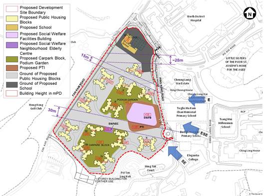
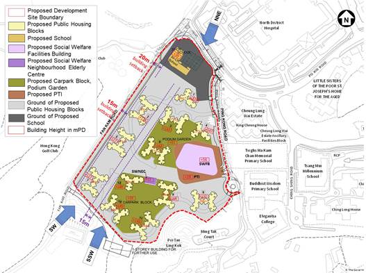
The proposed public housing development in Sub-area 1 comprises a total of 12 residential blocks with building heights ranged from the tallest point of 164mPD (48 storeys) in the middle descending outwards to 127mPD (37 storeys). With a total land area of about 80,000m2 and the maximum domestic plot ratio of 6.5 and non-domestic plot ratio is 0.5. The overall domestic GFA is 520,000m2 and non-domestic GFA is 40,000m2. It is anticipated that upon completion of this proposed public housing development, the maximum flat production of approx. 12,000 with household size of 2.8 will be yielded to meet the community needs. It will also accommodate a total population of about 33,600 upon full development.to meet the soaring housing demand in the community. In order to have a better visual permeability and air ventilation, three west-east airpath / visual corridors (i.e. one with 30m wide in the south, one with 15m in the middle and one with 15m in the north) are provided. Provision of one major wind channels across the north and south sides of the Site with at least 15m building separations is provided. The airpath/visual corridors are shown in the drawings below. Additionally, a public transport interchange (“PTI”) will be provided near Ping Kong Road, such interchange will benefit all residents and users for the proposed public housing development. All welfare facilities will be accommodated inside the podium and or above the PTI. A proposed Master Layout Plan of Sub-area 1 with the indication of the proposed building heights (in mPD) are provided in Figure 11.12. Section of the proposed public housing development is provided in Figure 11.14.1.

Layout Plan of the Site with Building Separations (E to W directions)  

Layout Plan of the Site with Building Separations (N to S directions)


11.4.4

Regarding Sub-areas 2-4, this area will be designated as “Other Specified Uses” annotated “Recreation cum Conservation”, primary intention is to conserve the existing natural landscape and ecological features, to provide space for recreational and ancillary facilities with minimal new structure/change to existing site conditions, serving the needs of the general public. No works would be carried out in Sub-area 4 (subject to further design development).  In Sub-area 2, a 1-storey building may possibly be provided nearby the existing pumping station for Sub-areas 2 to 4 for future use. Since the proposed public housing development in Sub-area 2 is subject to confirmation, the tentative footprint and its associated open area and road access are illustrated separately in Appendix 11.4.  

Site Area (meter square) (approx.)

90,000

Net Site Area (meter square) (approx.)

80,000

Domestic Plot Ratio

6.5

Domestic Gross Floor Area (meter square) (approx.)

520,000

Maximum Flat Production (approx.)

12,000

Average Household Size

2.8

Number of Domestic Blocks

12

Preliminary Building Heights in mPD and No. of Storeys for Domestic Blocks

127mPD to 164mPD[1]

37 to 48 storeys

Building Heights in mPD and No. of Storeys for Non-domestic Block (including social welfare facilities and PTI)

56mPD

7 storeys

Estimated Design Population

33,600

Non-Domestic Plot Ratio

0.5

Proposed Non-Domestic GFA (m2), of which:

40,000

Ø  Local Retail (m2)

10,000

Ø  Kindergartens (m2)

24 classrooms / approx. 2,200

Ø  Community Hall (m2)

1,260

Ø  Other non-domestic facilities

26,540

Social Welfare Facilities (m2

26,000 (5% of domestic GFA) of which:

Ø  18,000 for proposed social welfare facilities as requested by Social Welfare Department as at 25 November 2021.

Ø  8,000 reserved for the social welfare facilities

Private Car Parking Spaces


Ø  Private Car Parking Spaces

1,690  

Ø  Car Parking Spaces (Visitor Parking)

60

Ø  Non-van Type Light Goods Vehicle and Private Light Bus Parking Spaces

50

Ø  Medium / Heavy Goods Vehicle and Coach Parking Spaces

24

Public Car Parking Spaces

300

Public Transport Interchange

1 no.

Provision of Local Open Space

Not less than 33,600sqm

Provision of Green Area

Min 16,000 sqm

Target Year of Population Intake

2029

Remarks:

1.       Proposed GFA for non-domestic facilities includes local retail: approx. 10,000m2; kindergartens: approx. 2,200m2, community hall: approx. 1,260 m2 and other non-domestic facilities: approx. 26,540m2 For the social welfare facilities, 5% of domestic GFA (i.e.26,000 m2) have been provided. Up till 25 November 2021, proposed social welfare facilities requested by SWD accounts for 18,000sqm out of 26,000sqm. The remaining 8,000sqm will be reserved for social welfare facilities, details of such facilities subject to SWD’s confirmation.


  1. Due to the constraints for the location of the proposed school site’s access, additional space for internal access road of school site shall be provided within the school. In view of this, the overall school site will be greater than the standard requirements provided in HKPSG.


  1. The Study recommended a development proposal at Sub-area 1 of the FGC Site for a maximum of about 12,000 public housing flats with a PRH/SSF ratio of 70:30, which could fully utilise the traffic infrastructure capacity, the area suitable for housing development, and attain a maximum domestic plot ratio of 6.5. The actual number and /or type of housing flats may be subject to change depending on the development layout/parameters and other development constraints /requirements including infrastructure provision to be agreed in the detailed design stage.


  1. The development parameters in the table are for assessment purpose only and are subject to change at the detailed design stage.  

11.5          ASSESSMENT METHODOLOGY

11.5.1           Landscape Impact Assessment (LIA)

11.5.1.1           Pursuant to Clause 3.4.11.2 of the EIA Study Brief No. ESB-318/2019, the assessment area for the landscape impact assessment includes all areas within a 500m distance from the PDA as shown in Figure 11.2. The LIA covers the following tasks:

11.5.1.2     Identification of the existing Landscape Resources (LR) and sensitive Landscape Character Areas (LCA) found within the assessment boundary.  This is achieved by desktop study of topographical maps, information databases, photographs and subsequent site visits for verification.  The existing and planned landscape resources and character of the assessment area will be described, appraised, analyzed and evaluated. Descriptive text will provide a concise and reasoned judgement from landscape point of view will be provided. The sensitivity of landscape framework and its ability to accommodate change will be focused on particularly. Cumulative impacts of the proposed public housing development with other committed planned developments will be also assessed. Annotated oblique aerial photographs and plans of suitable scale showing the baseline landscape character areas and landscape resources and mapping of impact assessment shall be extensively used to present the findings of impact assessment. Photographs and plans of suitable scale will be used to show the location and existing condition of baseline LCA and LR. Landscape areas of high landscape value such as country park, coastal protection area, greenbelt, conservation area, watercourse and woodland areas will be identified. Any guidelines on landscape urban design strategies and frameworks that may affect the appreciation of the proposed public housing development will be also reviewed. If the proposed public housing development is found to have conflict with the statutory town plan(s) and published land use plans, they will be highlighted, and appropriate action will be followed up.  

11.5.1.3     Tree Survey A tree survey will be undertaken to estimate the numbers of existing trees, dominant species, maturity, rarity, Old and Valuable Trees (OVT) – trees on unleased government land within build-up areas or tourist attraction spots in village areas and fulfil one of the criteria of large size/ tree of precious or rare species/ particularly old age/ cultural, historical or memorable significance or outstanding form, tree of large size and species that are rare or protected such as Aquilaria sinensis. Based on the proposed development Option 2, Sub-area 1 is proposed for development while Sub-areas 2-4 are proposed to be preserved for compatible use.  Therefore, individual tree survey will be carried out for Sub-area 1 while broad brush tree survey will be provided for Sub-areas 2-4.  The survey will also be carried out and addressed the impacts on the existing trees. The findings will recommend for the retention or creation a buffer zone for identified landscape areas of high landscape value, such as country park, green belt, conservation area, watercourses and woodland areas will form part of the urban design strategies, layout and framework for the proposed public housing development. The tree survey plan can be found in Appendix 11.1.

11.5.1.4     Assessment of the degree of sensitivity of the LR and LCA Degree of sensitivity is assessed by a number of factors, including whether the LR or LCA is common or rare, whether it has any local, regional, national or global importance, whether there are any statutory or regulatory limitations/ requirements, quality, maturity and the ability of the LR or LCA to accommodate change.  Sensitivity of each LR and LCA is classified as follows:

High

High quality/ important landscape or landscape resource of particularly distinctive character or high importance, sensitive to relatively small changes.

Medium

Medium quality of landscape or landscape resource of moderately values landscape characteristics, reasonably tolerant to changes.

Low

Low quality of landscape or landscape resource, largely tolerant to change.

11.5.1.5     Identification of potential sources of landscape impacts The potential landscape impacts will be quantified as far as possible so as to illustrate the significance of such impacts arising from the proposed public housing development. These are the various elements of the construction works and operation procedures, such as removal of vegetation during site clearance, site formation, road improvement works, slope works, hoarding, etc. that would potentially generate landscape impacts.  Potential sources of impacts to the landscape character of the heritage setting will be identified. Clear mapping of the landscape impact will be required.

11.5.1.6     Assessment to the potential magnitude of change in LR or LCA The magnitude of change (or magnitude of impact) depends on a number of factors including the scale of LR/ LCA affected, the physical extent of the impact, the compatibility of the proposed public housing development with the existing and planned landscape setting, the landscape heritage setting, recreation and tourism related uses, and scenic spot, duration of the impact and reversibility of the change. Landscape impacts are quantified wherever possible.  The magnitude of change for LR and LCA is classified as follows:


Labgrge

The landscape or landscape resource would suffer from a major change and large scale of LR/ LCA to be affected.

Intermediate

The landscape or landscape resource would suffer from a moderate change and medium scale of LR/ LCA to be affected.

Small

The landscape or landscape resource would suffer from slight or barely perceptible change and small scale of LR/ LCA to be affected.

Negligible

The landscape or landscape resource would suffer from no discernible change and LR/ LCA to be unaffected.


11.5.1.7     Assessment of the impact significance for landscape without mitigation measures By synthesizing the magnitude of change and sensitivity of the identified LR and LCA, it is possible to categorize impacts in a logical, well-reasoned and consistent fashion. Table 11.1 shows the rationale for dividing the degree of significance into four thresholds, insubstantial, slight, moderate, and substantial. The thresholds depend on the combination of a negligible, small, intermediate, or large magnitude of change with a low, medium or high degree of sensitivity to change of landscape resource/ character. A derivative for judging the landscape and visual impact significance as required under the Annexes 10 and 18 of the EIAO-TM. Cumulative landscape and visual impacts of the proposed public housing development with other existing, committed and planned developments in the assessment area shall be assessed.  Additionally, planned developments in Kwu Tong North New Development Area (NDA), which falls outside the 500m distance, from the site boundary will be also considered.

Table 11.1- Relationship between Sensitivity and Magnitude of Change in Assessing Impact Significance

Magnitude of Change

Large

Moderate

Moderate / Substantial

Substantial

Intermediate

Moderate / Slight

Moderate

Moderate / Substantial

Small

Slight

Slight / Moderate

Moderate

Negligible

Insubstantial

Insubstantial

Insubstantial


Low

Medium

High


Sensitivity to Change

Note: All impact significance will be adverse unless otherwise stated.  Thresholds are defined below.

Substantial – The proposed public housing development will cause significant adverse deterioration/ beneficial improvement to the existing landscape.

Moderate – The proposed public housing development will cause a noticeable adverse deterioration/ beneficial improvement to the existing landscape.

Slight – The proposed public housing development will cause a slight adverse deterioration/ beneficial improvement to the existing landscape.

Insubstantial – The proposed public housing development will cause no discernible change to the existing landscape.


11.5.1.8     Identification of potential landscape mitigation measures The purpose of mitigation is to avoid, reduce and where possible, remedy or offset the adverse effects on the landscape arising from the proposed works.  Avoidance of the impact will be given priority.  If avoidance is not possible, alternative strategies to reduce, offset or compensate for the landscape impact will be explored. 2 types of mitigation measures will be considered.  They are as follows:

·                                   Primary mitigation measures – these are mitigation measures embedded into the proposed public housing development design and developed through an iterative design process.  This will mainly involve the adoption of alternative location, layout, design, built form and construction method of the architectural and built structural elements.

·                                   Secondary mitigation measures – These are mitigation measures proposed to specifically reduce or compensate for the unavoidable adverse landscape impacts arising from the proposed public housing development.  Measures that will consider the potential enhancement of existing landscape quality will also fall under this category.  These shall include edge landscape treatment for the proposed public housing development to blend in with the surrounding environment and minimize potential adverse impact on existing LR and LCA, especially those with high sensitivity.  

11.5.1.9     Assessment of residual landscape impact By synthesizing the magnitude of change and sensitivity of the identified LR and LCA, it is possible to categorize impacts in a logical, well-reasoned and consistent manner. The merits of preservation in totality, in parts or total destruction of existing landscape and the establishment of a new landscape character area will be evaluated. Table 11.1 shows the rationale for dividing the degree of significance into four thresholds, insubstantial, slight, moderate, and substantial. The thresholds depend on the combination of a negligible, small, intermediate, or large magnitude of change with a low-medium-high degree of sensitivity of landscape resource/ character.

11.5.2          Visual Impact Assessment (VIA)

11.5.2.1           Pursuant to Clause 3.4.11.2 of the EIA Study Brief No. ESB-318/2019, the assessment area for the visual impact assessment includes all areas within the visual envelope of the PDA as shown in Figure 11.4.

11.5.2.2           The VIA will also make reference to the visual context and the affected existing and planned visual sensitive receivers identified in the EIA Study being carried out for this project (Agreement No. CE17/2019(CE) - Technical Study on Partial Development of Fanling Golf Course Site) and include findings and recommended mitigation measures concluded therein. The VIA covers the following tasks:

11.5.2.3          Identification and plotting of the Visual Envelope The visual envelope is the viewshed of the proposed public housing development formed by natural or man-made features.  It will be based on desktop study of topographic maps, street maps, photographs, cross-sections to determine visibility and subsequent site visits.  Estimated heights of the new structures are used to determine their visibility within the visual envelope. Assessment of the visual envelope can be limited by the absence of height data for the new buildings in the assessment. Existing vegetation will be assessed in their current condition and assumed to remain at similar height and density. To identify the location of the visual envelope, the Visual Sensitive Receiver Plan in Figure 11.5 will be referred.

11.5.2.4          Appraisal of Existing Visual Resources and Character as well as the future outlook of the Visual System of the Assessment Area This is achieved by desktop study of topographical maps, information databases, photographs and subsequent site visits for verification. Existing visual character of the heritage setting will be evaluated.  Photographs and plans of suitable scale will be used to show the location and existing condition of visual resource and character.  

11.5.2.5          Identification of VSR The key groups of existing and planned sensitive receivers within visual envelope will be identified, with regards to views from ground level and elevated vantage points. The sensitive receivers on a plan of appropriate scale will be indicated clearly. VSR are defined as a person whose views within the Visual Envelope (VE) will be affected by the proposed public housing development during the construction and / or operation phase.  The location of key and representative VSR within the VE will be identified with justifications of selection provided.  VSR with similar views and sensitivity will be grouped into a key group for further assessment.  Key groups of existing and planned VSR within the VE with regard to views from ground level, and elevated vantage point will be identified and mapped. The VSR are classified according to whether a person is at home, at work, at play, or travelling and are detailed below. 

a)      Those who view the impact from homes are highly sensitive as the character of view quality from their home will have a substantial effect on their perception of quality, acceptability of their home environment and their general quality of life. People residing in temporary accommodation, such as hotels, are also considered highly sensitive as the view is a key pricing factor in room cost. These VSR are termed Residents.

b)      Those who view the impact from their workplace and leisure activities are relatively less sensitive to the character of the view. The view is considered to have a less important effect on their perception to quality of life. These VSR are termed Workers and Recreational Users.

c)      Those who view the impact while travelling in public/private vehicles or on foot will display varying sensitivity depending on the speed, nature and frequency of travel. These VSR are termed Travellers.

11.5.2.6          Identification of Key Public Viewing Points (VP) - VP will be selected as representative viewpoints for photomontage.  VP are key public viewing points that will be affected by the proposed public housing development during the construction and / or operation phase.  VP can be kinetic or static.  They include key pedestrian nodes, popular public areas for recreational activities, rest, leisure, sitting-out areas, walking, sight-seeing and prominent travel routes.  VP will be assessed at human eye level. The location of VPs is shown in Figure 11.6.

11.5.2.7          Identification of visual elements.  A description of the key visual elements within the sight of VP will be reported.  These may include any major physical structures, visual resources or attractors, visual eyesores or detractors that currently exist of are known to be planned within the Visual Envelope.  Potential impact to views to ridgelines will also be reviewed.

11.5.2.8          Assessment of sensitivity of VSR Factors considered when assessing VSR sensitivity to change include the type of VSR, quality of existing views, type and estimated number of receiver population, alternative views, duration or frequency of view, and degree of visibility. The sensitivity of the VSRs is classified as follows:

High

The VSR is highly sensitive to any change in their viewing experience.

Medium

The VSR is moderately sensitive to any change in their viewing experience.

Low

The VSR is only slightly sensitive to any change in their viewing experience.


11.5.2.9          Identification of potential sources of visual impacts Visual compatibility of the proposed public housing development with surrounding, planned setting and character of the heritage setting, its obstruction and interference with key views of the study areas, and changes in visual amenity will be provided in the assessment. Severity of visual impacts in term of distance, nature and number of sensitive receivers will be identified. These are the various elements of the construction works and operation procedures that have potential to cause visual impacts. The glare impacts of the proposed public housing development will be considered in the assessment. Assessment on effectiveness of the proposed mitigation measures of visual impacts during the construction and operation phases stages will be carried out by comparing the impacts with and without mitigation measure. Potential glare impacts arising from the proposed public housing development will be evaluated with reference to the “Charter on External Lighting” and “Guidelines on Industry Best Practices for External Lighting Installations” by Environmental Bureau.

11.5.2.10      Assessment of the potential magnitude of change to VSR The magnitude of change depends on a number of factors including the compatibility of the proposed public housing development with the surrounding landscape; duration of impacts; scale of impact; reversibility of the impact; distance of the source of impact from the viewer; and degree of visibility of the impact and the degree that the impact dominates the field of vision of the viewer.  The magnitude of change is classified as follows:

Large

The VSRs will experience a major change in the character of their existing views.

Intermediate

The VSRs will experience a moderate change in the character of their existing views

Small

The VSRs will experience a small change in the character of their existing views.

Negligible

The VSRs will experience no discernible change in the character of their existing views.

11.5.2.11      Prediction of the impact significance of visual impacts without mitigation measures By assessing the magnitude of change and the sensitivity of VSR, the degree of significance of the impacts are categorised as adverse/ beneficial and irreversible/ reversible.   Table 11.2 shows the rationale for dividing the degree of significance into four thresholds, namely, Insubstantial, Slight, Moderate and Substantial, depending on the combination of a magnitude of change and sensitivity of VSR.  Separate assessment will be made for construction phase and operation phase impacts.

Table 11.2 - Relationship between Sensitivity and Magnitude of Change in Assessing Impact Significance

Magnitude of Change

Large

Moderate

Moderate / Substantial

Substantial

Intermediate

Moderate / Slight

Moderate

Moderate / Substantial

Small

Slight

Slight / Moderate

Moderate

Negligible

Insubstantial

Insubstantial

Insubstantial


Low

Medium

High


Sensitivity to Change

Note: All impact significance will be adverse unless otherwise stated.

Substantial – The proposed public housing development will cause significant adverse deterioration/ beneficial improvement to the existing visual quality.

Moderate – The proposed public housing development will cause a noticeable adverse deterioration/ beneficial improvement to the existing visual quality.

Slight – The proposed public housing development will cause a slight adverse deterioration/ beneficial improvement to the existing visual quality.

Insubstantial – The proposed public housing development will cause no discernible change to the existing visual quality.

11.5.2.11   Identification of the potential visual mitigation and enhancement measures These may take the form of adopting alternative designs or revisions to the basic engineering, preservation of vegetation and existing landscape resources, infrastructure and architectural designs to prevent and/ or minimise adverse impacts, remedial measures such as colour and textural treatment of built structures, landscape design and greening; compensatory measures such as tree planting. The agencies responsible for the funding, implementation and management/ maintenance of mitigation measures will be identified and detailed.  The visual mitigation measures will be recommended for construction phase and operation phase.

11.5.2.12   Prediction of the impact significance for visual impacts after the implementation of mitigation measures By assessing the magnitude of change and the sensitivity of VSR, the degree of significance of the impacts are categorised as adverse/ beneficial and irreversible/ reversible. Table 11.2 shows the rationale for dividing the degree of significance into four thresholds, namely, Insubstantial, Slight, Moderate and Substantial, depending on the combination of a magnitude of change and sensitivity of VSR.

11.5.3          Glare Impact Assessment

11.5.3.1          As required in para. 3(v) and 4, Appendix J of the EIA Study Brief No. ESB-318/2019, the glare impacts of the proposed public housing development shall be considered in the assessment. Assessment on effectiveness of the proposed mitigation measures of visual impacts during the construction and operation phases stages shall be carried out by comparing the impacts with and without mitigation measures.

11.5.3.2          While the EIAO Guidance Note No. 8/2010 provides general guidance on the preparation of “Landscape and Visual Impact Assessment” under the Environmental Impact Assessment Ordinance, currently, there are no standardised objective assessment criteria or guideline from local authorities with respect to glare impact assessment for statutory approval process in HKSAR. 

11.5.3.3           According to the EIAO-TM, glare is included as one of the potential visual impact sources which would cause uncomfortable eye feeling by direct or indirect light source. Since glare impact or uncomfortable eye feelings are subjective, a qualitative approach shall be adopted to conduct the assessment.

11.5.3.4          Charter on External Lighting” and “Guidelines on Industry Best Practices for External Lighting Installations” promulgated by the Environment Bureau shall be referred to evaluate the potential glare impacts due to man-made light sources produced from the proposed public housing and associated works, in order to make recommendation on practicable mitigation measures. 

11.5.4          Mitigation Measures

11.5.4.1          The mitigation measures will not only be concerned with damage reduction but also include consideration of potential enhancement of existing landscape and visual quality.  Parties shall be identified for the management and maintenance works of the proposed mitigation measures to ensure their effectiveness throughout the construction and operation phase of the proposed public housing development, associated works, supporting facilities and essential infrastructures.  A practical programme and funding proposal for the implementation, management and maintenance of the recommended landscape and visual mitigation measures and parties responsible from design to operation stage shall be provided.

11.5.4.2          The Construction Phase Measures listed in Table 11.10 shall be adopted from the commencement of construction and shall be in place throughout the entire construction period. The Operation Phase Measures shall be adopted during the detailed design stage and be built as part of the construction works so that they are in place at the date of commissioning of the proposed public housing development. Tree Planting Works will be commenced as soon as the site is available for planting.

11.5.4.3           Annotated illustration materials such as colour perspective drawings, plans, section/ elevation diagrams, annotated oblique aerial photographs, photographs taken at viewing points, and computer-generated photomontage will be adopted to fully illustrate the landscape and visual impacts of the proposed public housing development. The landscape and visual impacts of the proposed public housing development with and without mitigation measures from representative viewpoints, particularly from views of the most severely affected visually sensitive receivers, will be illustrated in existing and planned setting at four stages (existing condition, Day 1 with no mitigation measures, Day 1 with mitigation measures and Year 10 with mitigation measures) by computer-generated photomontage in order to demonstrate the effectiveness of the proposed mitigation measures. Computer graphic will be compatible with Microstation DGN file format.  The technical details in preparing the illustration will be recorded and it will be submitted for verification of the accuracy of the illustration. If any noise barrier/ enclosures are proposed, the colour, design and materials will be selected as compatible with the surrounding buildings and the development context and their aesthetic designs will be also considered.

11.5.5           Overall Assessment

11.5.5.1           An overall assessment of the acceptability of the residual impacts has been carried out to determine whether the landscape and visual impacts are beneficial, acceptable, acceptable with mitigation measures, unacceptable or undetermined.  The description of the assessment result is shown in Table 11.3.

Table 11.3 - Assessment of Acceptability of Overall Impacts

Assessment of Acceptability of Overall Impacts

Description

Beneficial

The proposed public housing development will complement and enhance the landscape and visual character and quality and follow the planning objective.

Acceptable

The proposed public housing development will have no significant effects on the landscape or visual quality and no interference with key views.

Acceptable with mitigation measures

The proposed public housing development will cause some adverse effects, but these can be eliminated, reduced or offset to a large extent with mitigation measures.

Unacceptable

The proposed public housing development will cause adverse effects considered too excessive and unable to mitigate practically.

Undetermined

The impact is undetermined because significant adverse effects are likely, but the extent to which they may occur or may be mitigated cannot be determined from the study. Further detailed study will be required for specific effects in question.


11.6          LANDSCAPE BASELINE CONDITION

11.6.1    Landscape Resources

Existing LRs are identified within the assessment boundary.  Their sensitivity is provided in Table 11.4.  Locations of the baseline LRs are indicated in Figure 11.2 - Figure 11.2.9 and photographs of identified LRs can be found in Figure 11.7.1-11.7.5.

Table 11.4 - Baseline Landscape Resources (LRs) and Sensitivity

LRs

Description

Sensitivity

LR1 Woodland

LR1.1 

Natural Woodland in Golf Course

(29.04ha)

This is an area of heavily vegetated with mature trees to the natural woodland located within Golf Course. 224 nos. of Trees of Particular Interest (TPI), (179 nos. Aquilaria sinensis, 4 nos. Cinnamomum camphora, 29 nos. Glyptostrobus pensilis, 12 nos. Melaleuca cajuputi subsp. Cumingiana) and 36 nos. of plants under Cap. 586 (4 nos. Ardisia villosa, 21 nos. Aristolochia tagala, 8 nos. Glyptostrobus pensilis and 3 nos. Rhododendron simsii) are identified as conservation importance within LR1. 

Dominant species include Macaranga tanarius (血桐), Lophostemon confertus (紅膠木), Aquilaria sinensis (土沉香), Melaleuca cajuputi (白千層), Schefflera heptaphylla (鴨腳木), Glyptostrobus pensilis (水松), Hibiscus rosa-sinensis L. (大紅花), Alocasia macrorrhizos (海芋), Ligustrum sinense (山指甲). They are generally in fair condition and range from 5m to 14m in height.  None of the TPI and plants with conservation importance will be affected. None of the TPIs and plants with conservation importance will be affected.


Quality:  High

Importance / Rarity:  High Importance / Rare

Ability to Accommodate Change: Low

Local / Regional Significance: High / Medium

Maturity: Semi-mature – Mature

High

LR1.2

Secondary Woodland in Golf Course

(35.28ha)

This area refers to fairway trees and secondary woodland in the Golf Course.  Rare and protected species can be found within this LR. 111 nos. of Trees of TPI (82 nos, Aquilaria sinensis, 9 nos. Cinnamomum camphora, 16 nos. Melaleuca cajuputi subsp. Cumingiana., 1 no. Adenanthera microsperma, 1 no Ficus macrocarpa and 2 nos. Eucalyptus exserta) and 19 nos. of plants under Cap. 586 (7 no. Ardisia villosa, 1 nos. Aristolochia tagala, 1 no. Artocapus hypargyreus, 9 nos. Cibotium barometz, 1 no. Peperomia blanda) are identified as conservation importance within LR1.2. 

Dominant species include Macaranga tanarius (血桐), Cinnamomum camphora (), Lophostemon confertus (紅膠木), Sterculia lanceolate (假蘋婆), Melaleuca cajuputi (白千層) and Acacia confuse (台灣相思). They are generally in fair condition and range from 5-16m in height. 


18 nos. of the TPI and 9 nos. of plants with conservation importance will be affected by the proposed public housing development in Sub-area 1. 1 no. of TPI will be affected by the proposed public housing development in Sub-area 2.

Quality:  High

Importance / Rarity:  High Importance / Rare

Ability to Accommodate Change: Low

Local / Regional Significance: High / Medium

Maturity: Semi-mature – Mature

High

LR1.3

Construction Site

(4.63ha)

This LR, located by the New Territories Circular Road, is now a construction site for North District Hospital Expansion.  


Dominant species such as Melaleuca cajuputi Roxb. subsp. cumingiana (白千層), they are in fair in condition and range from 7m to 10m in height.


Quality:  Medium

Importance / Rarity:  Medium Importance

Ability to Accommodate Change: High

Local / Regional Significance: High / Medium

Maturity: Semi-mature - Mature

Low

LR1.4

Natural Woodland by Sheung Yue River

(2.09ha)

This area is a natural woodland located by Sheung Yue River. This is a very common and local hillside landscape feature in Hong Kong which provides natural green backdrop for surrounding areas. Feng Shui woodland can be identified as part of this LR.


Dominant species include Leucaena leucocephala (銀合歡), Acacia confuse (台灣相思), Macaranga tanarius var. tomentosa (血桐), Ficus virens (大葉榕), Alocasia macrorrhizos (海芋), Sterculia lanceolate (假蘋婆), Ardisia quinquegona (羅傘) and Schefflera heptaphylla (鴨腳木). They are generally poor to fair in condition and range from 8m to 17m in height.  

Quality:  High

Importance / Rarity:  High Importance / Rare

Ability to Accommodate Change: Low

Local / Regional Significance: High / Medium

Maturity: Semi-mature - Mature

High

LR1.5

Woodland by Tai Lung Experimental Farm

(15.17ha)

This LR is a natural woodland with partial shotcrete artificial slopes near Tai Lung Experimental Farm and dense woodland further.

Dominant tree species found include, Aquilaria sinensis (土沉香), Syzyglum jambas (蒲桃), Mallotus paniculatus (白楸), Cinnamomum cassia (肉桂), Eucalyptus robusta () and Ficus microcarpa (細葉榕). The trees range from 5-10m in height and generally in fair condition. Dominant shrubs and ground covers found are Litsea rotundifolia (豺皮樟), Dicranopteris pedata   (芒萁). Climbers found on trees are Epipremnum aureum (綠蘿) can be seen climbing over the existing trees. 


Quality:  High

Importance / Rarity:  High Importance / Rare

Ability to Accommodate Change: Low

Local / Regional Significance: High / Medium

Maturity: Mature

High

LR1.6

Shrubland/ Grassland

(6.57ha)

This LR is a natural shrubland and grassland on the hilltop within Golf Course.  Plantings are non-maintained, and some graves are found in this area.

Quality:  Medium

Importance /Rarity:  Medium Importance / Uncommon

Ability to Accommodate Change: High

Local / Regional Significance: Medium / Low

Maturity: Young

Low

LR2 Grassland

LR2 Grassland

(62.08ha)

This LR refers to the areas are mainly covered by grass in Golf Course. It also includes some ornamental plantings and sand bunkers as part of the golf course design. Graves can be also found scattering within this LR. 104 nos. of Trees of Particular Interest (TPI) (94 nos. Aquilaria sinensis, 1 no. Cinnamomum camphora, 7 nos. Melaleuca cajuputi subsp. Cumingiana, 1 no. Celtis sinensis and 1 no. Ilex graciliflora). and 1 no. of plants under Cap. 586 (1 no. Aristolochia tagala) are identified as conservation importance within LR2. 


Dominant plant species found include various grasses such as Zoysia Matrella (溝葉結縷草), Axonopus compressus (地毯草) and Platinum Paspalum, Calliandra haematocephala (朱纓花), Bougainvillea spectabilis (簕杜), Phyllanthus myrtifolius (錫蘭葉下珠) and Kalimeris indica (馬蘭).  22 nos. of TPI will be affected by the proposed public housing development in Sub-area 1 and 1 no. of TPI will be affected by the proposed public housing development in Sub-area 2.

Quality:  High

Importance / Rarity:  Medium Importance / Rare

Ability to Accommodate Change: High

Local / Regional Significance: High / Medium

Maturity: Young

Low

LR3 Agricultural Land

LR3.1

Tai Lung Experimental Farm

(0.99ha)

This LR is situated within an AFCD gated area next to the Hong Kong Golf Club, with chain-link fence around it. Trees in this area are semi-mature to mature trees in fair condition and maintained by government departments. 

 Dominant tree species include, Melaleuca cajuputi Roxb. subsp. cumingiana (白千層), Acacia confuse (台灣相思), Leucaena leucocephala (銀合歡), Alangium chinen (八角楓), Mallotus paniculatus (白楸), Ficus hispida (對葉榕), Bombax ceiba (木棉) Dimocarpus longan (龍眼), Eucalyptus citriodora (檸檬桉) and dominant shrub species include Alocasia macrorrhizos (海芋).

Quality:  Medium

Importance /Rarity:  Medium Importance / Uncommon

Ability to Accommodate Change: Medium

Local / Regional Significance: Medium / Medium

Maturity: Semi-mature – Mature

Medium

LR3.2

Agriculture Land Area

(81.66ha)

This land consists of mainly orchard farms with rusty chain-linked fences and unpaved dirt road. The roadside area is covered with invasive species such as Leucaena leucocephala (銀合歡), Bidens alba (白花鬼針草) Lantana camara (馬纓丹), Alocasia macrorrhizos (海芋), Mikania micrantha (薇金菊) and Triadica sebifera (烏桕). 1 no. of Trees of Particular Interest (TPI) (Aquilaria sinensis) is identified. 

Common vegetable plants include mature size Musa x paradisiaca L. (大蕉), Carica papaya (番木瓜), Ananas comosus (菠蘿), Saccharum officinarum (甘蔗) and Dimocarpus longan (龍眼). None of the TPIs will be affected.


Quality:  Medium

Importance / Rarity: Medium Importance / Uncommon

Ability to Accommodate Change: Medium

Local / Regional Significance: High / Medium

Maturity: Semi-mature – Mature

Low

LR4 Watercourse

LR4.1

Watercourse in Golf Course

(0.11ha)

This LR consists of mainly several small, trapezoidal and concrete lined channels running through the Golf Course. Some small ditches with poor quality water are found on the South of Old Course. No trees or shrubs are located within this LR. Common vegetations were recorded in this area, including Brachiaria mutica (巴拉草), Kyllinga polyphylla (水蜈蚣), Bidens alba (白花鬼針草) and Alocasia macrorrhizos (海芋).

Quality:  Medium

Importance / Rarity:  Medium Importance / Uncommon

Ability to Accommodate Change: Medium

Local / Regional Significance: Medium / Low

Maturity: Young

Medium

LR4.2

Pond in Golf Course

(0.56ha)


There is a total of 3 ponds identified within the Golf Course. One is located in PDA and others are appeared within 500m assessment area. They are found to be actively managed but the use of them are uncertain. Aquatic plants such as Nymphaea spp. (睡蓮), Canna indica (美人蕉) and Panicum repens (鋪地黍) can be observed and no trees are located within this LR. 

Quality:  Medium

Importance / Rarity: Medium Importance / Uncommon

Ability to Accommodate Change: Medium

Local / Regional Significance: Medium / Low

Maturity: Young

Medium

LR4.3

Wetland in Golf course

(0.14ha)

This LR is a wetland located to the South of PDA. This habitat has been derived from poorly drained fields with rainwaters retained or flooded by the overflows. It can support growth of wetland plant species.

Dominant species such as Brachiaria mutica (巴拉草), Commelina diffusa (節節草), Polygonum chinense (火炭母), Canna indica (美人蕉) and Panicum repens (鋪地黍). No trees are located within this LR. 

Quality:  Medium

Importance / Rarity:  Medium Importance / Rare

Ability to Accommodate Change: Medium

Local / Regional Significance: Medium / Low

Maturity: Young

Medium

LR4.4

Watercourse

(3.65ha)

This is a watercourse. It is widened in phases for drainage improvement of coastal plain and lowland areas in Northwest New Territories to resolve the flooding problem. It is densely to moderately vegetated and some native tree species are growing on the channel side of watercourse as well as behind the retaining wall.


Dominant species include Leucaena leucocephala (銀合歡), Ficus microcarpa (細葉榕), Ligustrum sinense (山指甲), Alocasia macrorrhizos (海芋), Wedelia chinensis (三裂葉蟛蜞菊) and Syngonium podophyllum (合果芋).


Quality:  Medium

Importance / Rarity:  High Importance / Rare

Ability to Accommodate Change: Medium

Local / Regional Significance: High / Medium

Maturity: Semi-mature

Medium

LR5 Residential Area

LR5.1

Low Density Residential Area

(14.23ha)

This LR is a low-rise residential development of lower density dominated by housing blocks of 2-3 stories interwoven with small roads and paths.

Dominant species found include Ficus microcarpa (細葉榕), Acacia confusa (台灣相思), Leucaena leucocephala (銀合歡), Chrysalidocarpus lutescens (散尾葵), Roystonea regia (王棕), Senna siamea (鐵刀木), Ficus microcarpa 'Golden Leaves' (黃金榕), Cordyline fruticose (朱蕉) and Duranta repens (金連翹). Trees range from 8-12m in height and are generally semi-mature to mature. They are mainly in fair condition. 

Quality: Medium

Importance/ Rarity:  Medium Importance / Uncommon

Ability to Accommodate Change: Medium

Local / Regional Significance: Medium / Low

Maturity: Young – Semi-mature

Medium

LR5.2

Built Up Area

(15.33ha)

This LR consists of high-rise buildings in public and private residential areas. It is well-maintained with flowering tree and shrub species. Tree height range from 4-12m in height and they are generally in fair condition.

Dominant species found include Ficus microcarpa (細葉榕), Aleurites moluccana (石栗), Ficus virens (大葉榕), Podocarpus macrophyllus (羅漢松), Delonix regia (鳳凰木), Michelia x alba (白蘭), Duranta repens (金連翹), Schefflera heptaphylla (鴨腳木), Rhododendron simsii (杜鵑), Ixora spp. (龍船花), Bouganvillea spectabilis (簕杜鵑) and Aglaia odorata (米仔蘭).

Quality:  Medium

Importance / Rarity: Medium Importance / Uncommon

Ability to Accommodate Change: Medium

Local / Regional Significance: Medium / Low

Maturity: Semi-mature – Mature

Medium

LR5.3

Village Environs

(10.72ha)

This LR is an area with low-rise buildings connected by narrow footpaths and lanes.  There are ancestral halls, sitting-out areas, public washroom, car parks, abandoned lands, agricultural fields, rural industrial areas and scattered fruit trees. 1 no. of Trees of Particular Interest (TPI) (Cinnamomum camphora) is identified within LR5.3. 

Dominant species found include Ficus microcarpa (細葉榕), Acacia confusa (台灣相思), Leucaena leucocephala (銀合歡), Macaranga tanarius var. tomentosa (血桐), Bauhinia x blakeana (洋紫荊), Bouganvillea spectabilis (簕杜鵑), Bidens alba (白花鬼針草) and Wedelia chinensis (蟛蜞菊). Tree height range from 7-15m in height and they are generally in fair to poor condition.  None of the TPIs will be affected.


Quality:  Medium

Importance /Rarity:  Medium Importance / Uncommon

Ability to Accommodate Change: Medium

Local / Regional Significance: Medium / Low

Maturity: Semi-mature - Mature

Medium

LR5.4

Tendered for Private Development

(0.41ha)

This LR is located at the junction between Fan Kam Road and Castle Peak Road (Kwu Tung). It was tendered for private residential development since 30 June 2021. No tree is found within the LR.

Plant species found include Ligustrum sinense (山指甲), Alocasia macrorrhizos (海芋), Camellia azalea (杜鵑紅山茶) and the dominant species are Ixora spp. (龍船花), Asparagus densiflorus (狐尾天門冬) and Rhapis excelsa (棕竹).

Quality:  Medium

Importance /Rarity:  Medium Importance / Uncommon

Ability to Accommodate Change: High

Local / Regional Significance: Medium / Low

Maturity: Young

Medium

LR6 Community facilities

LR6.1

North District Hospital

(5.93ha)

This LR located at Po Kin Road is an acute general hospital serving the population of the New Territories East Cluster. Trees and vegetations were planted scattering in the LR and at the periphery of the site.   

Dominant species found include Eucalyptus citriodora (檸檬桉), Ficus microcarpa (細葉榕), Michelia x alba (白蘭), Ixora spp. (龍船花) and Hibiscus rosa-sinensis (大紅花). Trees range from 6-15m in height and are generally semi-mature to mature. They are mainly in fair condition and well-maintained.  

Quality:  Medium

Importance /Rarity:  Medium Importance / Uncommon

Ability to Accommodate Change: Medium

Local / Regional Significance: Medium / Low

Maturity: Semi-mature – Mature

Medium

LR6.2

Little Sisters of the Poor St. Joseph's Home for the Aged

(3.14ha)

This LR, located at Po Kin Road, is a private residential care home for elderly and recognised service provider. It is inaccessible to the public, yet a landscape courtyard with ornamental plantings can be observed from the street.

Dominant species found include Caryota mitis (短穗魚尾葵), Ficus virens (大葉榕), Polyalthia longifolia (印度塔樹) and Agave angustifolia (龍舌蘭). Other species found include Acacia confusa (台灣相思), Delonix regia (鳳凰木), Bombax ceiba (木棉), Bauhinia x blakeana (洋紫荊), Livistona chinensis (蒲葵), Ficus pandurate Hance (琴葉榕), Juniperus chinensis (龍柏), Hibiscus mutabilis (木芙蓉), Duranta repens (金連翹), Allamanda cathartica (軟枝黃蟬), Bouganvillea spectabilis (簕杜鵑), Ficus microcarpa cv. Golden Leaves (黃金榕), Hibiscus rosa-sinensis L. (大紅花), Carmona microphylla (福建茶) and Gloriosa superba (嘉蘭). Trees range from 6-13m in height and are generally semi-mature to mature. They are mainly in fair condition and well-maintained.

Quality:  Medium

Importance /Rarity:  Medium Importance / Uncommon

Ability to Accommodate Change: Medium

Local / Regional Significance: Medium / Low

Maturity: Semi-mature – Mature

Medium

LR6.3

Catholic Diocese of Hong Kong Mother of Christ Church

(0.38ha)

This LR is a low-rise modern church at Po Ping Road and was built in 1990. It provides recreational use in form of lawn area and some potted plants appear to be placed by the staircases. Amenity planting strips are found at the front part of the site as visual screening. It is managed and maintained by Catholic Diocese of Hong Kong. It is open to the public.

Dominant species found include Cinnamomum camphora (), Chrysalidocarpus lutescens (散尾葵), Juniperus chinensis (龍柏), Bouganvillea spectabilis (簕杜鵑), Aglaia odorata (米仔蘭) and Clerodendrum thomsonae (龍吐珠Trees range from 5-15m in height and are generally semi-mature to mature. They are mainly in fair condition and well-maintained.

Quality:  Medium

Importance /Rarity:  Medium Importance / Uncommon

Ability to Accommodate Change: Medium

Local / Regional Significance: Low / Low

Maturity: Semi-mature – Mature

Medium

LR6.4

Buddhist Li Chong Yuet Ming Nursing Home for the Elderly

(0.40ha)

This LR is an area of high-rise building providing nursing home service for elderly at Po Ping Road. Some planting areas are found located nearby vehicular path and carpark to enhance the environment. Tree height range from 5m-10m in height. The species are generally fair in condition and well-maintained. 

Dominant tree species found include Celtis sinensis (朴樹), Bauhinia x blakeana (洋紫荊), Hibiscus rosa-sinensis (大紅花) and Loropetalum chinense (紅繼木). Other species found include Ficus virens (大葉榕), Ficus pandurata (琴葉榕), Chrysalidocarpus lutescens (散尾葵), Codiaeum variegatum (變葉木), Camellia japonica (茶花) and Syngonium podophyllum (合果芋).

Quality:  Medium

Importance /Rarity:  Medium Importance / Uncommon

Ability to Accommodate Change: High

Local / Regional Significance: Low / Low

Maturity: Semi-mature – Mature 

Medium

LR7 School

LR7

School

(3.09ha)

This LR refers to four different school campuses with private amenity plantings in planters situated along Ching Shing Road. All schools are mostly fenced off by concrete walls. Tree plantings along concrete walls inside schools can be observed from the street level.

Dominant tree species found include Bauhinia x blakeana (洋紫荊), Melaleuca bracteata (黃金串錢柳), Juniperus chinensis (龍柏), Hedychium coronarium (薑花), Schefflera heptaphylla (鴨腳木) and Lagerstroemia speciosa (大花紫薇). Other species found include Melaleuca cajuputi subsp. cumingiana (白千層), Callistemon viminalis (串錢柳), Ficus benjamina (垂葉榕), Hibiscus rosa-sinensis (大紅花) and Ixora spp. (龍船花). The trees are 5 - 10m in height and generally in average condition.

Quality:  Medium

Importance / Rarity:  Low Importance / Uncommon

Ability to Accommodate Change: Medium

Local / Regional Significance: Low / Low

Maturity: Semi-mature - Mature

Medium

LR8 Recreation Area

LR8.1

Golf Club Building

 (3.22ha)

This LR is a low-rise clubhouse which was recognized as historical and heritage building (Grade 2). It is one of the historic buildings in the Golf Course. Ornamental plantings and seasonal flowers are found in the recreational areas.


Species such as Ficus virens (大葉榕 Eucalyptus exserta (窿緣桉), Celtis sinensis (朴樹), Melaleuca cajuputi subsp. cumingiana (白千層), Cinnamomum camphora () can be observed with PDA in this area.  4 nos. of TPI (1 no. Lophostemon confertus, 1 no. Ficus virens, 1 no. Eucalyptus citriodora and 1 no. Celtis sinensis located in LR8.1, 1 no. of them with high amenity.  2 nos. of the TPI will be affected by the proposed proposed public housing development in Sub-area 1.


Dominant tree species found include, Bauhinia spp. (羊蹄甲屬), Cinnamomum burmannii (陰香), Leucaena leucocephala (銀合歡), Schefflera heptaphylla (鴨腳木), Juniperus chinensis (龍柏), Carmona microphylla (福建茶), Cordyline fruticosa (朱蕉), Cuphea hyssopifolia (細葉雪茄花) and Phyllostachys nigra (黃金竹). Tree height range from 8m-20m in height and generally fair in condition. 

Quality:  High

Importance / Rarity:  High Importance / Rare

Ability to Accommodate Change: Low

Local / Regional Significance: High / Medium

Maturity: Semi-mature - Mature

High

LR8.2

Carpark in Golf Course

(1.15ha)

This LR is a private carpark with sitting out area managed by HKGC within PDA. Most plantings are found along the edge of carpark facing to the Fan Kam Road. There are 2 nos. of tree with high amenity value within this area. Tree heights range from 5m-15m and are mostly mature. 5 nos. of TPI (1 no. Aquilaria sinensis, 2 nos. Melaleuca cajuputi subsp. Cumingiana and 2 no. Pterocarpus indicus) located in LR8.2.  3 nos. of the TPI will be affected by the proposed public housing development in Sub-area 1. Trees are generally in fair condition.


 Dominant species found include Melaleuca cajuputi subsp. cumingiana (白千層), Celtis sinensis (朴樹), Cinnamomum camphora (), Caryota mitis (短穗魚尾葵), Schefflera arboricola (鵝掌藤), Codiaeum variegatum (變葉木), Phyllanthus urinaria (葉下珠), Dracaena trifasciata (虎尾蘭).

Quality: Medium

Importance /Rarity:  Medium Importance / Uncommon

Ability to Accommodate Change: Medium

Local / Regional Significance: Medium / Medium

Maturity: Semi-mature – Mature

Medium

LR9 Sitting-out Area

LR9.1

Po Wing Road Sitting-out Area

(0.06ha)

This LR is situated at Po Wing Road. It provides recreational use for pets in form of sitting out spaces with play equipment for dogs, ancillary facilities and maintained planting areas.

Trees found include Delonix regia (鳳凰木), Chrysalidocarpus lutescens (散尾葵), Bauhinia x blakeana (洋紫荊), Lagerstromeia speciose (大花紫薇), Ficus virens (黃葛樹), Melaleuca cajuputi Roxb. subsp. cumingiana (白千層) and Callistemon viminalis (串錢柳). Generally, the trees are in fair condition and are range from semi-mature to mature.

Shrubs species include Ixora spp. (龍船花), Excoecaria cochinchinensis (紅背桂), Loropetalum chinense f. rubrum (紅繼木), Schefflera heptaphylla (鴨腳木), Cordyline fruticosa (朱蕉), Rhapis excelsa (棕竹), Murraya paniculata (九里香), Hibiscus rosa-sinensis L. (大紅花) and Duranta repens `Variegata` (花葉連翹).

Quality:  Medium

Importance / Rarity:  High Importance / Uncommon

Ability to Accommodate Change: Low

Local / Regional Significance: High / Medium

Maturity: Semi-mature – Mature

Medium

LR10 Temporary Use

LR10

Towngas Offtake Station, Waterworks Depot and Open Storage Yards (6.90ha)

This LR is currently occupied by Towngas offtake station, waterworks depot and open storage yards. There are some tree species such as Leucaena leucocephala (銀合歡), Bauhinia x blakeana (洋紫荊), Bauhinia variegata (宮粉羊蹄甲), Lagerstroemia speciosa (大花紫薇) and Celtis sinensis (朴樹) found yet amenity plantings can be barely observed. The trees are not well maintained and in fair to poor quality. They found are self-seeded species.


Quality:  Low

Importance / Rarity:  Low Importance / Common

Ability to Accommodate Change: High

Local / Regional Significance: Low/ Low

Maturity: Semi-mature  

Low

LR11 Transportation Corridor

LR11.1

Fanling Highway

(4.37ha)

This LR refers to the roadside and roundabout planting along Fanling Highway. Trees in this plantation are from young to semi-mature, including mainly Melaleuca bracteate (黃金串錢柳), Leucaena leucocephala (銀合歡), Macaranga tanarius var. tomentosa (血桐). The trees are mostly non-maintained and generally in fair condition. 1 no. Trees of Particular Interest (TPI) (Aquilaria sinensis) is identified.


Dominant shrub species found include Ixora spp. (龍船花), Loropetalum chinense f. rubrum (紅繼木), Ficus microcarpa (黃金榕) and Nerium oleander (粉花夾竹桃). None of the TPIs will be affected.


Quality:  Medium

Importance / Rarity:  Low Importance / Common

Ability to Accommodate Change: High

Local / Regional Significance: Medium / Low

Maturity: Young - Semi-mature  

Low

LR11.2

Local Transportation Corridor


(8.75ha)

This LR refers to the local roadsides with plantation to create buffer along the Fan Kam Road, Ching Hiu Road, Ping Kong Road and Po Kin Road which provides good screening effect and enhances the overall landscape quality of the surrounding environment. Trees are generally in fair condition.  Tree height range from 5-9m in height and are mostly semi-mature. 

Dominant tree species found include Bauhinia x blakeana (洋紫荊), Melaleuca cajuputi (白千層), Cinnamomum camphora (), Michelia x alba (白蘭), Bombax ceiba (木棉), Ixora spp. (龍船花), Loropetalum chinense f. rubrum (紅繼木) and Calliandra haematocephala (紅絨球).

Quality: Medium

Importance / Rarity:  Low Importance / Common

Ability to Accommodate Change: High

Local / Regional Significance: Medium / Low

Maturity: Semi-mature   

Low


11.6.2                Landscape Character Areas (LCAs)

Details of the baseline Landscape Character Areas which are potentially affected by the proposed public housing development, together with their sensitivity are described in Table 11.5.  The locations of baseline landscape character areas are mapped in Figure 11.3.  Photo illustrating the Landscape Character Areas within the Study Area are illustrated in Figure 11.8.

Table 11.5 - Landscape Character Areas (LCAs) and Sensitivity

LCAs

Description

Sensitivity

LCA1

Golf Course Landscape

(128.4ha)

This LCA located on the urban fringe, is a vegetated highly managed site. It contains mainly extensive areas of grassland managed for golf playing purposes, numerous mature trees and shrubs planting, footpaths, ponds, ancestral graves, built heritage buildings and carparking. It lies in mature wooded settings where views are more contained. The character of LCA is tranquil and verdant yet superficially informal.  The golf course consists of three 18-hole. They are Old Course obtained in 1911, New Course opened in 1931 and the Eden Course opened in 1971. Roadside amenity planting can be found along main vehicular routes. 


449 nos. of TPI (1 no. Adenanthera microsperma, 357 nos.Aquilaria sinensis, 2 nos. Celtis sinensis, 14 nos. Cinnamomum camphora, 1 no. Eucalyptus citriodora, 2 nos. Eucalyptus exserta, 1 nos. Ficus macrocarpa, 1 no. Ficus virens, 29 nos. Glyptostrobus pensilis, 1 no. Ilex graciliflora, 1 no. Lophostemon confertus, 37 nos. Melaleuca cajuputi subsp. Cumingiana, and 2 no. Pterocarpus indicus) and 56 no. of plants under Cap. 586 (11 nos. Ardisia villosa, 23 nos. Aristolochia tagala, 1 no. Artocapus hypargyreus, 9 nos. Geodorum densiflorum,, 8 nos. Glyptostrobus pensilis, 1 nos. Peperomia blanda and 3 nos. Rhododendron simsii) are identified as conservation importance within LCA1.  45 nos. of the TPI and 9 nos. of plants with conservation importance will be affected by the proposed public housing development in Sub-areas 1 and 2 nos. of TPI would be affected by the proposed layout in Sub-area 2.


Quality:  High

Importance / Rarity:  High Importance / Rare

Ability to Accommodate Change: Medium

Local / Regional Significance: High / Medium

Maturity: Semi-mature - Mature

High

LCA2

Residential Urban Landscape

(39.2 ha)

These are urban landscapes largely utilized for residential land use.  Medium and high-rise residential blocks developed on a relatively flat terrain set amongst open space with elevated footbridges and walkways connecting to retail / commercial facilities and shopping centres.  Schools and community facilities can also be found within this landscape.  Vegetation can be mainly found within the open spaces and around the residential estates on ground level and on podium.  They are fairly ordered landscaped with large building elements surrounded by planting and greenery.


Quality:  Medium

Importance / Rarity:  Medium Importance / Common

Ability to Accommodate Change: High

Local / Regional Significance: Medium / Low

Maturity: Semi-mature

Medium

LCA3

Urban Peripheral Village Landscape

(137 ha)

This LCA consists different villages that have been retained despite of the new development around them.  They are generally low-rise buildings connected by narrow footpaths and lanes. Surrounding the village are sitting-out areas, car parks, agricultural fields and scattered fruit trees.  Mature trees and vegetation can be found scattered around the periphery. 


2 nos. of TPI (1 no. Aquilaria sinensis, 1 no. Cinnamomum camphora) are identified within LCA3. None of the TPI or plant with conservation importance will be affected.


Quality:  Medium

Importance / Rarity:  Low Importance / Common

Ability to Accommodate Change: High

Local / Regional Significance: Low / Low

Maturity: Semi-mature - Mature

Medium

LCA4

Residential Urban Fringe Landscape

(11.3 ha)

This LCA is characterised by the semi-developed and disturbed areas of land. It is low-density residential landscapes in vegetated or wooded settings lying at the edge of urban area. It consists of individual houses, villas and low-rise apartments based around narrow roads interspersed by wooded hillsides and dense vegetation to soften the certain extent. This is a high green coverage residential landscape with a relatively informal and tranquil character.

Quality:  Medium

Importance / Rarity:  Low Importance / Common

Ability to Accommodate Change: High

Local / Regional Significance: Medium / Low

Maturity: Semi-mature – Mature

Medium

LCA5

Transportation Corridor Landscape

(4.4 ha)


This LCA is characterized as a linear landscape defined by Fanling Highway, associated facilities and roadside buffer planting.  They include mainly elevated roads, flyovers, footbridges and signages.  Roadside buffer planting can be found on both sides of the highway.


Quality:  Low

Importance / Rarity:  Low Importance / Common

Ability to Accommodate Change: High

Local / Regional Significance: Low / Low

Maturity: Young - Semi-mature

Low


11.6.3

Tree Survey

11.6.3.1

A total of 4411 nos. of trees were recorded in the Proposed Development Area (PDA) and adjacent area likely to be affected by the proposed works. 

11.6.3.2

1255 nos. of trees were identified in Sub-area 1 while 3090 nos. were in Sub-areas 2-4 of the PDA. A total of 53 trees under the maintenance of LCSD and 13 trees located within the private lot were identified outside the PDA. 

11.6.3.3

Among the 1255 nos. of surveyed trees in Sub-area 1, 70 nos. of Trees of Particular Interest (TPIs) were identified. 24 nos. are mature trees with DBHs equal to or over 1000mm and 46 nos. are rare/protected species

11.6.3.4

Among the 46 nos. rare/protected species (including 1 no. Ilex graciliflora), 38 are Aquilaria sinensis, of which 7 nos. are trees with DBHs equal to or over 95mm and 31 are seedlings or young trees with DBHs smaller than 95mm.

11.6.3.5

Among the 1255 nos. of trees recorded in Sub-area 1, 267 nos. are proposed to be retained while 988 nos. of existing trees recorded in Sub-area 1 are estimated to be affected by the proposed public housing development works. Among the 988 nos. of affected trees, 954 nos. of trees are proposed to be removed and 34 nos. are proposed to be transplanted. 

11.6.3.6

Among the 24 nos. of mature trees with DBH over than 1000mm in Sub-area 1, 11 nos. are feasible to preserve on site per the adjusted layout of the works and 2 nos. are suitable to transplant to nearby receptor site within the PDA. 11 nos. of mature trees are proposed to be removed due to proximity with the proposed building layout and thus in-situ retention is not feasible. For mature trees proposed to be preserved, tree islands should be properly formed to mitigate the impacts of large-scale site formation works. The 32 individuals of rare/protected species cannot be preserved on site but worthwhile to transplant within or off site are proposed to be transplanted to nearby suitable receptor site. 

11.6.3.7

Among the approx. 3090 nos. of existing trees in Sub-area 2-4 recorded in a broad-brush tree survey represented by 73 tree groups, 395 nos. of TPIs were recorded. 41 nos., including 1 no. dead tree, are mature trees with DBHs equal to or over 1000mm and 80 nos. are rare/protected species including Aquilaria sinensis (43 nos.) and Glyptostrobus pensilis (30 nos.), Lagerstroemia indica (2 nos.) and L. speciosa (5 nos.).  Locations of trees are shown in Appendix 11.1.  All of the existing trees in Sub-areas 2-4 are proposed to be retained as proposed public housing development has no direct impact on the concerned trees

11.6.3.8

Regarding the adjacent area, amongst the 66 nos. of existing trees recorded in the adjacent areas outside PDA (53 trees under the maintenance of LCSD and 13 trees located within the private lot), 24 trees are proposed to be retained. 42 nos. of trees, including 7 Leucaena leucocephala (undesirable species) and 35 nos. of trees are proposed to be removed due to direct conflict with the proposed works. No rare and protected species are proposed to be felled in adjacent areas outside PDA.

11.6.3.9

To compensate the loss of 996 nos. trees, 996 nos. of compensatory trees are proposed to be planted in Sub-areas 2-3 or other suitable location[2].  Exact receptor sites for compensatory trees are subject to future site planning during detail design stage.


11.6.3.10

A total of 34 nos. of trees are proposed to be transplanted from Sub-area 1 to Sub-areas 2-3 or other suitable location, including 32 rare/protected species and 2 mature trees with DBH of 1000mm. Figure 11.9.1 - Mitigation Plan (Overall) is shown the receptor site of transplanted trees.

11.6.3.11

No registered “Old and Valuable Trees” (OVT) were recorded during the tree survey. 

11.6.3.12

Regarding the plants (non-tree species) with conservation importance, there will be 9 nos. of plants to be affected by the proposed public housing development due to the conflict of proposed building footprint in Sub-area 1. These plants are proposed to be transplanted from Sub-area 1 to Sub-area 3 of the PDA. Figure 11.9.1 – Mitigation Plan (Overall) is shown the receptor site of the transplanted plants. The location of the affected plants with conservation importance is shown in Appendix 11.3 – Vegetation Plan (Non-tree Species).

11.6.3.13

In addition to the above, all of the existing trees in Sub-areas 2-4 are proposed to be retained except 2 nos. of TPIs - T33 and T61 would be affected by the proposed public housing development in Sub-area 2. Transplantation of these trees are not feasible, T33 is located on slope crest with DBH over 1000mm, preparation of its root ball for transplantation is not feasible. T61 is in close proximity to other trees to be retained, transplantation of this tree will affect the other trees. Therefore, these trees are proposed to be removed. 2 nos. of compensatory tree are proposed for the loss of tress in Sub-area 2. Since the proposed public housing development in Sub-area 2 is subject to confirmation, details of the affected TPIs are separately provided in Appendix 11.5[3].  


11.7          VISUAL BASELINE CONDITION

11.7.1     Visual Sensitive Receivers (VSR)

11.7.1.1

The visual envelope (VE) is the viewshed of the proposed public housing development formed by natural or man-   made features.  It includes areas from which the proposed public housing development can be completely visible, partly visible or obstructed.

11.7.1.2

The VE is largely limited by existing vegetation, infrastructures, existing developments and mountain ridgelines of Kai Kung Leng (approx. 580mPD), Tai To Yan (to the south) (approx. 560mPD), and Cham Shan (approx. 100mPD) and Wa Shan (to the north) (approx. 139mPD). An aerial plan showing the location of VE is provided in (Figure 11.4).

11.7.1.3

Areas to the north of the Site by Sheung Shui MTR station are high density, mixed residential and commercial areas.  The urban fringe comprises of medium-rise to low-rise industrial buildings located northwest to the Site, which gradually transitions to rural fringe setting with village settlements and agriculture towards the South.  The Site is currently a golf course comprising lawns, sand pits, water resources and trees.  

11.7.1.4

The major visual resources of this district include Lam Tsuen Country Park (including Tai To Yan and Kai Kung Leng ridgeline), south of the Site, and Fanling Golf Course, west of the Site.  The main visual detractor is Fanling Highway located north of the Site. Since the Site is currently occupied by natural landscape with only few low-rise buildings in the foreground, therefore the visual openness to most of its public is good and the visual quality of the region is generally within the range of medium to good.  

11.7.1.5

The VSRs within the VE have been identified.  Their locations are shown in Figure 11.5Details of the VSRs are given in the below table.


Table 11.6 – Description of VSR


ID

VSR Name

Approx. Viewing Distance (m)

Type of VSR (Residents, Workers, Students, Travellers, Recreational Users)

Quality of Existing View (Good Fair Poor)

Alternative View (Yes, No)

Degree of Visibility (Full, Partial, Glimpse, Obstructed)

Duration of View

(Long, Medium, Short)

Frequency of View (Frequent, Occasional, Rare)

Population (Many, Some, Few)

Sensitivity (Low, Medium, High)


Visual Analysis of Key Visual Sensitive Receivers


VSR1

Ching Ho Estate

155m

Residents

Good

Yes

Full

Long

Frequent

Many

High

The existing view is composed of low-rise primary and secondary schools with roadside planting provided in the foreground. The disposition of schools allows viewing corridor for this VSR. To the south, viewers enjoy views of scattered village house and high ridgelines in the background. Quality of view is good.


Due to the long duration of stay of residents in this location, the relatively close distance towards the proposed public housing development (approximately 155m from VSR1) and the proposed public housing development will form a permanent change in their viewing experience, the sensitivity of viewers at this VSR is considered high.


VSR2

Cheung Lung Wai Estate

17m

Residents

Good

Yes

Full

Long

Frequent

Many

High

These viewers currently enjoy a good panoramic view towards the greenery of Fanling Golf Course without building blockage in front, quality of view is good.


Due to the long duration of stay of residents in this location, the extremely close distance towards the proposed public housing development (approximately 17m from VSR2) and the proposed public housing development will form a permanent change in their viewing experience, the sensitivity of viewers at this VSR is considered high.


VSR3

Tai Ping Estate


365m

Residents

Fair

Yes

Partial

Long

Frequent

Many

High

The existing view of this VSR is fair, views are partially blocked by medium-rise buildings in east and west. However, viewers at the high building level enjoy relatively good view towards the greenery of Fanling Golf Course. Quality of view is fair.


Considering that viewers in this VSR are mainly residents and the population is large with high frequency of view, the sensitivity of viewers at this VSR is considered high.


VSR4

Eden Manor

430m

Residents

Good

Yes

Full

Long

Frequent

Many

High

These viewers currently enjoy good view towards the greenery of Fanling Golf Course without blockage in the foreground and high ridgelines in the background, quality of view is good.


VSR4 is approximately 430m from the proposed public housing development which would form a permanent new feature view and the relatively long duration of stay for the viewers, the sensitivity of viewers is considered high.


VSR5

On Po Tsuen

403m

Residents

Good

Yes

Full

Long

Frequent

Some

High

The existing ground level view is dominated by mixture of low-rise village houses, intermittent greening and village facilities.  Viewers enjoy good panorama view towards the greenery of Fanling Golf Course at medium-high level. Quality of view is good.


The proposed public housing development would be in a medium distance (approximately 403m) and permanent. Though at ground level, this area is surrounding by planting and village houses, the proposed public housing development is still apparent due to close distance, blocking most of the existing views. The sensitivity of viewers at this VSR is considered high


VSR6

Ping Kong Village

100m

Residents

Good

Yes

Full

Long

Frequent

Some

High

The existing view is composed of village houses and village facilities in the foreground, medium-rise residential and mountain ridgelines in the background.  Greenery of Fanling Golf Course can be seen in medium-high level, quality of view is considered good.


Considering of the relatively close distance (approximately 100m) from the proposed public housing development and the long duration of stay for the viewers, the sensitivity of viewers is high.


VSR7

Ling Tong Mei Tsoi Yuen

1,300m

Residents

Fair

Yes

Obstructed

Long

Frequent

Few

Low

View at ground level are largely blocked by low-rise residential estates at the west and dominated by natural woodland at the east and south, quality of view for this VSR is fair.


Since the viewing distance from the viewers is not so visible to the proposed public housing development (approx. 1,300m) and the population of this VSR is very limited, therefore the sensitivity of viewers is low.


VSR8

Miami Crescent

1,500m

Residents

Good

Yes

Full

Long

Frequent

Some

Medium

Currently, the viewers enjoy good and panorama view towards the existing natural greenery without building blockage in the front, quality of view is considered good.


Although approximately 1,500m from the proposed public housing development, given the good panoramic nature of the existing views, sensitivity of viewers of this VSR is considered medium.


VSR9

Tai Lung

1,000m

Residents

Good

Yes

Glimpse

Long

Frequent

Some

Medium

The existing view is composed of natural woodland in the foreground and scattered village houses behind it, quality of view for this VSR is good.


Considering the relative long distance towards the proposed public housing development and the relatively small amount of population in this VSR, the sensitivity of viewers is medium.


VSR10

Lin Tong Mei

1,280m

Residents

Good

Yes

Glimpse

Long

Frequent

Some

Medium

This VSR is a mix of low-rise village houses with intermittent greening and roadside plantation, the viewers enjoy a low angle natural woodland view in the foreground. Quality of view is good.


Considering the relative long distance towards the proposed public housing development and the relatively small amount of population in this VSR, the sensitivity of viewers is medium.


VSR11

Tai Lung Experimental Farm

740m

Workers

Good

Yes

Glimpse

Medium

Occasional

Some

Medium

Currently, viewers enjoy natural woodland in the foreground, scattered low-rise structures in the mid-ground and the Fanling Golf Course at the background. Quality of view is good.


Although VSR11 is approximately 740m from the proposed public housing development and it would be a permanent new feature in the view, given the relatively small group of people and frequency of view is occasional, sensitivity of viewers at this VSR is considered medium.


VSR12

Hong Kong Canine Working and Agility Club Ltd.

525m

Workers

Good

Yes

Partial

Medium

Occasional

Some

Medium

The composition of views includes existing green area from Hong Kong Canine Working and Agility Club Limited in the foreground and ridgeline in the background.  Quality of view is good.


Although VSR12 is approximately 525m from the proposed public housing development and it would be a permanent new feature in the view, given the relatively small group of people and frequency of view is occasional, sensitivity of viewers at this VSR is considered medium.


VSR13

North District Hospital

95m

Workers / Patients / Members of General for Receiving Medical Services

Good

Yes

Partial

Medium

Frequent

Some

Medium

Although part of the view is blocked by the high-rise residential buildings at the north east, given that roadside plantation in the foreground and greenery of Fanling Golf Course can be seen from high level, quality of view is good.


Considering that viewers in this VSR are mainly workers, patients and general for receiving medical services, which is relatively small group of people and the duration of stay is medium, thus, the sensitivity of viewers at this VSR is considered medium.


VSR14

Buddhist Li Chong Yuen Ming Nursing Home for the Elderly

340m

Workers and Elderly Residing at the Home for Elderly

Good

Yes

Glimpse

Long

Frequent

Some

Medium

Although part of the view is blocked by North District Hospital at the south west, given that green area at the foreground, Fanling Golf Course and North District Equestrian Events Memorial Garden at the background can be seen from medium level, quality of view is good.


Considering that viewers in this VSR are mainly workers and elderly, which is relatively small group of people and the duration of stay is medium, thus, the sensitivity of viewers at this VSR is considered medium.


VSR15

Mother of Christ Church

365m

Workers, Recreational Users

Good

Yes

Glimpse

Medium

Occasional

Some

Medium

The composition of view of this VSR includes the natural woodland in the foreground and Fan Kam Road in the mid-ground. Greenery of Fanling Golf Court and North District Equestrian Events Memorial Garden can be seen from medium high level. Quality of view is good.


Considering that viewers in this VSR are mainly workers and recreational users, which is relatively small group of people and the duration of stay is medium, thus, the sensitivity of viewers at this VSR is considered medium.


VSR16

Ping Kong Tin Hau Temple

160m

Recreational Users

Good

Yes

Full

Short

Rare

Few

Medium

The existing view is occupied by village facilities, access roads and scattered village houses, quality of view is considered good.


Although the relatively close distance (approximately 160m) from the proposed public housing development, given that the number of recreational users is relatively rare, and their duration of stay is short, the sensitivity of viewers is medium.


VSR17

Tung Wah Group of Hospitals Ma Kam Chan Memorial Primary School

10m

Workers & Students

Good

Yes

Full

Medium

Occasional

Some

Medium

Composition of view of this VSR includes the school facilities and greening area in the foreground with Ping Kong Road at the back. Greenery of Fanling Golf Course can be seen from medium height level, quality of view is good.


Although the extremely close distance (approximately 10m) from the proposed public housing development, given that the number of workers is relatively rare, and their duration of stay is medium, therefore the sensitivity of viewers is medium.


VSR18

HKCKLA Buddhist Wisdom Primary School

30m

Workers & Students

Good

Yes

Full

Medium

Occasional

Some

Medium

Similar with VSR17, the existing view is occupied by school facilities in the foreground with Ping Kong Road behind it. Greenery of Fanling Golf Course can be seen from medium height level, quality of view is good.


Although the extremely close distance (approximately 30m) from the proposed public housing development, given that the number of workers is relatively rare, and their duration of stay is medium, therefore the sensitivity of viewers is medium.


VSR19

Elegantia College

43m

Workers & Students

Good

Yes

Full

Medium

Occasional

Some

Medium

Currently, view of this VSR is blocked by medium-high building in the front, given that cluster of woodland can be seen in the west, quality of view is good.


Although the extremely close distance (approximately 43m) from the proposed public housing development, given that the number of workers is relatively rare, and their duration of stay is ‘medium’, sensitivity of viewers is medium.


VSR20

Tsang Mui Millennium School

155m

Workers & Students

Fair

Yes

Partial

Medium

Occasional

Some

Medium

Existing view is surrounded by high-rise residential buildings at the eastern and southern sides. Views also partially blocked by medium-high schools and hospital at the west.  Quality of view of this VSR is fair.


Although the relatively close distance (approximately 155m) from the proposed public housing development, given that the number of workers is relatively limited, and their duration of stay is medium, therefore the sensitivity of viewers is medium.


VSR21

The Hong Kong Golf Club

110m

Recreational Users

Good

Yes

Partial

Medium

Occasional

Some

Medium

The dominant view of this VSR is Fanling Golf Course by which the view is wide and open, therefore quality of view is good.


Although the relatively close distance (approximately 110m) from the proposed public housing development, given that the number of recreational users is relatively limited, and their duration of stay is medium, therefore the sensitivity of viewers is medium.


VSR22

Planned Housing Developments at Sheung Shui Areas 4 & 30 Sites 1 & 2

1,250m

Residents

Fair

Yes

Partial

Long

Frequent

Many

Medium

Existing view is composed of mix of village houses and woodland, Shek Sheung River forms the foreground view of this VSR. Quality of view is fair.


Although there is approximately 1,250m away from the proposed public housing development, given that viewers in this VSR are mainly residents with long duration of stay and population is large, the sensitivity of viewers at this VSR is considered medium.


VSR23

Wu Tip Shan Hiking Trail

1,500m

Recreational Users

Good

No

Full

Short

Occasional

Few

Low

This VSR representing viewers participating in outdoor activities along the trails, with good and panoramic view of Sheung Shui and Fanling with Shenzhen in the background. The mountain ridgeline can also be seen in the back, stretching from Kai Kung Leng to Crest Hill and Wa Shan. Quality of view is good.


Given the relatively long distance (approximately 1,500m) from the proposed public housing development, the short duration of stay and the relatively few amounts of population of this VSR, the sensitivity of view is low.


VSR24

Lam Tsuen Country Park Hiking Trail

2,740m

Recreational Users

Good

Yes

Partial

Short

Occasional

Few

Low

Representing viewers participating in outdoor activities along the trails, with good views to the Fanling town centre, various hill ranges and scattered village houses. The quality of view is good.


Given the relatively long distance (approximately 2,740m) from the proposed public housing development, the short duration of stay and the relatively few amounts of population of this VSR, the sensitivity of view is low.


VSR25

Wa Shan Hiking Trail

2,740m

Recreational Users

Good

No

Glimpse

Short

Occasional

Few

Low

View dominated by Fanling town center and hill ranges, view to the north over Shenzhen can also be seen. Quality of view is good.


Given the relatively long distance (approximately 2,740m) from the proposed public housing development, the short duration of stay and the relatively few amounts of population of this VSR, the sensitivity of view is low.


VSR26

Fan Kam Road

1m

Travellers

Fair

Yes

Full

Short

Rare

Many

Medium

The existing view is dominated by roadside plantation. Although views will be transient and less valuable than static views and would have a very short duration to perceive the view, given the extremely close distance to the proposed public housing development, the sensitivity of viewers at this VSR is considered medium.


VSR27

Fanling Highway

480m

Travellers

Fair

Yes

Glimpse

Short

Rare

Many

Low

The existing view is composed of several clusters of natural woodland, roadside plantation, scattered village houses and high-rise residential estate. The quality of view is fair with a broad view of mixed visual components.

Views will be transient and less valuable than static views and would have a very short duration to perceive the view, and the relatively far away from the proposed public housing development, the sensitivity of viewers at this VSR is considered low.


VSR28

Fanling Town Center

1,570m

Residents

Fair

Yes

Partial

Long

Frequent

Many

Medium

The composition of views for this VSR includes Fanling MTR station, Fanling Highway in the foreground, scattered village houses in the mid-ground and Wu Tip Shan at the background view. The quality of view is fair.


Although VSR28 is approximately 1,570m from the proposed public housing development, given that the numbers of population are large, and the frequency of view is high, the sensitivity of viewers at this VSR is considered medium.


VSR29

Shek Wu Hui Jockey Club Playground

906m

Recreational Users


Fair


Yes

Partial

Short

Rare

Few

Low

View is dominated by the high-rise residential buildings of Po Shek Wu Estate and Choi Po Court in the foreground and midground respectively. Quality of view is considered fair.


Given the relatively long distance (approximately 906m) from the proposed public housing development, the short duration of stay and the relatively few amounts of population of this VSR, the sensitivity of view is low.


VSR30

Tai Tau Leng 12 Lane

575m

Residents

Fair


Yes


Partial


Long


Frequent

Few

Low

The composition of views for this VSR includes the village setting in the foreground, high-rise residential development in the midground and a partial view of the mountain ridgeline of Tai To Yan behind the existing buildings. Quality of view is considered fair.


Given the moderate distance and the few population of this group, sensitivity of viewers at this VSR is considered low.


VSR31

Kam Tsin Village Ho Tung School

1200m

Workers & Students

Fair

Yes

Partial

Short

Rare

Few

Low

Existing view is composed of existing vegetation, high-rise development, low -rise village housings and the mountain ridgeline of Tai To Yan, quality of view is fair.


Given the long distance from the proposed public housing development, few population of this group and short duration of stay, sensitivity of viewers at this VSR is considered low.


VSR32

Pak Wo Road Basketball Court

980m

Recreational Users

Fair

Yes

Partial

Short

Rare

Few

Low

Existing view is composed of existing trees, vegetation, car parking area and mountain ridgeline at the back.


Given the relatively long distance from the proposed public housing development, few populations of this group and short duration of stay, sensitivity of viewers at this VSR is considered low.


VSR33

Kwu Tung Reservoir

2700m

Recreational Users

Good

Yes

Partial

Short

Rare

Few

Low

Representing viewers participating in outdoor activities at the reservoir, with good views surrounded by existing woodland vegetation, water body and mountain ridgelines. The quality of view is good.


Given the relatively long distance (approximately 2,700m) from the proposed public housing development, the short duration of stay and the relatively few amounts of population of this VSR, the sensitivity of view is low.


VSR34

Hang Tau Village

2025m


Residents

Fair

Yes

Partial


Long


Frequent

Some

Low

Existing view is composed of vegetation, low-rise village housings, public toilets, overhead lines and electricity poles, quality of view is fair.


Considering the relative long distance towards the proposed public housing development and only some amount of population in this VSR, the sensitivity of viewers is low.


VSR35

Lei Wah San Tsuen

1731m


Residents

Fair

Yes

Partial


Long


Frequent

Some

Low

The composition of views for this VSR includes the existing village settlements and vegetations located alongside the village road. Low-rise residential blocks and woodland vegetation form the background view of this viewpoint.


Given the relatively long distance away from the proposed public housing development, and only some populations of this group, sensitivity of viewers at this VSR is considered low.


11.7.2    Key Public Viewing Point (VP)

11.7.2.1     As per the visual impact assessment methodology, key public viewing points (VP) have been selected to provide close, medium, and long-range views of the proposed public housing development.  The locations of the VP are given in Figure 11.6A description for each VP is below:

11.7.2.2     VP1 – Wa Shan- This VP is located along the hiking trail at Cham Shan at an   elevation of approximately 120mPD and represents the view from the North at a distance.  It gives a full panoramic view of Sheung Shui and Fanling with Lam Tsuen Country Park as a backdrop.  The mountain ridgeline of Kai Kung Leng, Tai To Yan, and Crest Hill can be seen. 

11.7.2.3     VP2 – Tai Tau Leng - This VP is located by the footpath adjacent Shek Sheung River by Tai Tau Leng at an elevation of approximately 4.8mPD and represents the view from the North at a moderate distance.  The view shows a village setting in the foreground, high-rise development in the midground, and a partial view of the mountain ridgeline of Tai To Yan behind existing buildings. 

11.7.2.4     VP3 – Wu Tip Shan – This VP is located at a look-out point along the hiking trail at an elevation of approximately 240mPD.  It represents distant views from the East.  This viewpoint gives a full panoramic view of Sheung Shui and Fanling with Shenzhen in the background.  The mountain ridgeline can also be seen in the back, stretching from Kai Kung Leng to Crest Hill and Wa Shan. 

11.7.2.5     VP4 – Ping Kong Road - The VP represents close views of the proposed public housing development from the west.  The photograph was taken along Ping Kong Road footpath (in front of Cheung Lung Wai Estate and Tung Wah Group of Hospitals Ma Kam Chan Memorial Primary School) at an elevation of approximately 14.5mPD. The existing view is dominated by Ping Kong Road at the front and existing trees, vegetations in the background.     

11.7.2.6     VP5 – Tai Lung Experimental Farm – This VP is located along a road by Tai Lung Experimental Farm at an elevation of approximately 50mPD.  It is located south of the Site.  The view towards the Site is partially screened by existing vegetation within the Farm.  High-rise developments can be seen through the gaps of the vegetation. 

11.7.2.7     VP6 – Shek Wu Hui Jockey Club Playground – This VP is located by Shek Wu Hui Jockey Club Playground and Sheung Shui Cycling Hub.  It represents close views from the North.  The photograph was taken at an elevation of approximately 7.9mPD.  The existing view is dominated by the foreground view of public road, the newly developed public housing estate - Po Shek Wu Estate forms the background view of this viewpoint.

11.7.2.8     VP7 – Pak Wo Road Basketball Court - This VP is located by Pak Wo Road     Basketball Court and represents moderate views from North-East.  The photograph was taken in front of Pak Wo Road Basketball Court at an elevation of approximately 17.6mPD, a private car parking area is located immediately in the foreground of this VP.  

11.7.2.9     VP8 – Footbridge by Kam Tsin - The VP is located on the footbridge and along Fanling Highway.  It represents distant views from the West.  The photograph was taken from a footbridge at an elevation of approximately 15mPD. The view towards the Site is partially screened by existing vegetation. High-rise developments, low-rise village housing, and the mountain ridgeline of Tai To Yan can be seen through the gaps of the vegetation.

11.7.2.10   VP9 – Lion Pavilion by Tong Kung Leng Basketball Court - The VP is located within the open space by Lion Pavilion.  It represents close views from the South.  The photograph is taken at an elevation of approximately 36.7mPD. The existing view is dominated by the sitting-out facilities in the foreground and vegetation in the background.

11.7.2.11   VP10 – Fanling Golf Course - The viewpoint was selected as representative views of recreational users in Fanling Golf Course.  It represents close views from the West.  The photograph was taken in the Fanling Golf, the view towards the Site is partially screened by existing vegetation within the golf course and along Fan Kam Road.  

11.7.2.12   VP11 – On Po Tsuen - The viewpoint was selected as representative views of residents of On Po Tsuen. It represents close views from the East. The photograph was taken at the eye level towards the Site. The existing view is dominated by mixture of low-rise village houses, intermittent greening and village facilities. 

11.7.2.13   VP12 – Elegantia College The viewpoint was selected as representative views of workers and students at the close views from the East.  The photograph was taken in front of Elegantia College, HKCKLA Buddhist Wisdom Primary School, Tsang Mui Millennium School and Ching Ho Estate towards the Site which is partially blocked by the existing schools. The existing view is dominated by HKCKLA Buddhist Wisdom Primary School and Cheung Lung Wai Estate to the east and Elegantia College to the west.

11.7.2.14   VP13 – Fan Kam Road - The viewpoint was selected as representative views of the travelers of Fan Kam Road. The existing view is dominated by roadside plantation. The view towards the Site is partially screened by existing roadside plantation and vegetation.   

11.7.2.15   VP14 – Kwu Tung Reservoir - The viewpoint was selected as representative views of the outdoor recreational users of Kwu Tung Reservoir. The existing view is dominated by woodland vegetations, water body and mountain ridgelines.  The view towards the Site is screened by existing woodland plantation and vegetation.  

11.7.2.16   VP15 – Hang Tau Village - The viewpoint was selected as representative views of residents of Hang Tau Village. It represents the long range of views from the West. The photograph was taken at the eye level towards the Site. The existing view is dominated by mixture of low-rise village houses and village facilities. 

11.7.2.17   VP16 – Lei Wah San Tsuen - The viewpoint was selected as representative views of the residents of Lei Wah San Tsuen. It represents the long range of view from the Northwest.  The view is dominated by the existing village settlements and vegetations located alongside the village road. Low-rise residential blocks and woodland vegetation form the background view of this viewpoint.

11.7.2.18 The following table indicate the represented VSRs by VP:


Key Public View Point (VP)

Visual Sensitive Receivers represented by VP

VP1 - Wa Shan

VSR25 – Wa Shan Hiking Trail

VP2 – Tai Tau Leng

VSR30 – Tai Tau Leng Lane 12

VP3 – Wu Tip Shan

VSR23 - Wu Tip Shan Hiking Trail

VP4 – Ping Kong Road

VSR2 – Cheung Lung Wai Estate

VSR17 (Tung Wah Group of Hospitals Ma Kam Chan Memorial Primary School)

VP5 – Tai Lung Experimental Farm

VSR11 – Tai Lung Experimental Farm

VP6 – Shek Wu Hui Jockey Club Playground

VSR29 – Shek Wu Hui Jockey Club Playground

VP7 – Pak Wo Road Basketball Court

VSR32 – Pak Wo Road Basketball Court

VP8 – Footbridge by Kam Tsin

VSR31 – Kam Tsin Village Ho Tung School

VP9 – Lion Pavilion by Tong Kung Leng Basketball Court

VSR10 – Lin Tong Mei

VP10 – Fanling Golf Course

VSR21 – Fanling Golf Course

VP11– On Po Tsuen

VSR5 – On Po Tsuen

VP12– Elegantia College

VSR1 - Ching Ho Estate

VSR18 – HKCKLA Buddhist Wisdom Primary School

VSR19 – Elegantia College

VSR20 -Tsang Mui Millennium School

VP13 – Fan Kam Road

VSR26 – Fan Kam Road

VP14 – Kwu Tung Reservoir

VSR33 - Kwu Tung Reservoir

VP15 – Hang Tau Village

VSR34 -Hang Tau Village

VP16 – Lei Wah San Tsuen

VSR35 - Lei Wah San Tsuen

Remarks:

VSR3 (Tai Ping Estate), VSR13 (North District Hospital), VSR14 (Buddhist Li Chong Yuen Ming Nursing Home for the Elderly), VSR15 (Mother of Christ Church), VSR27 (Fanling Highway) are located outside the adjacent VP4 and VP10, the visual impression of these VSRs can make reference to the nearest available VPs.  

Although VSR4 (Eden Manor) is located within the viewing angle of the nearest VP2, VP2 is located approx. 140m away from VSR4. Therefore, VP2 is not able to fully represent VSR4, the visual impression of this VSR can make reference to the nearest available VPs.  

VSR6 (Ping Kong Village) and VSR16 (Ping Kong Tin Hau Temple) are located outside the viewing angle of the nearest VP11, the visual impression of these VSRs can make reference to the nearest available VPs..

VSR7 (Lin Tong Mei Tsoi Yuen), VSR8 (Miami Crescent) and VSR24 (Lam Tsuen Country Park Hiking Trail) are located at the back of the nearest VP5 and VP9, the visual impression of these VSRs can make reference to the nearest available VPs..

VSR9 (Tai Lung) is located outside the viewing angle of the nearest VP5, the visual impression of this VSR can make reference to the nearest available VPs.

VSR12 (Hong Kong Canine Working and Agility Club Limited) is located at the back of the nearest VP11, the visual impression of this VSR can make reference to the nearest available VPs.

VSR22 (Planned Public Housing Development Sheung Shui Area No. 4 & 30 Site 1 & 2) is located at the west of the nearest VP6, the visual impression of this VSR can make reference to the nearest available VPs.

VSR28 (Fanling Town Center) is located at the back of the nearest VP7, the visual impression of this VSR can make reference to the nearest available VPs.


11.8          POTENTIAL SOURCES OF IMPACTS

Potential impacts would result from the temporary and permanent above ground structure elements during the construction and operation phase.  The sources of impacts are listed in the following table.

Table 11.7 – Potential Sources of Landscape & Visual Impacts


Code

Description

Construction Phase

C1

Removal of vegetation due to site clearance

C2

Site formation works & excavation works

C3

Construction of roads, PTI and associated facilities

C4

Construction of underground utilities

C5

Construction traffic

C6

Temporary site office, stockpiling, machinery and works area

C7

Potential glare generated from area flood light at night

C8

Dust from construction works

Operation Phase

O1

Operation of the proposed public housing development, PTI, carpark and associated facilities

O2

Permanent removal of existing trees and other vegetation


11.9            LANDSCAPE AND VISUAL IMPACT BEFORE MITIGATION

11.9.1          Landscape Resources

11.9.1.1          The magnitude of the unmitigated landscape impacts associated with the construction and operation phases of the proposed public housing development have been assessed and are summarized in Table 11.8.  A description of each affected LR and LCA is described below and mapping of the landscape impacts are shown in Figure 11.13.1- 11.13.4.

11.9.1.2          LR1.1 Natural Woodland in Golf Course - There would be a small impact due to site formation and loss of vegetation in Golf Course.  Total area affected is approximately 0.13ha, which constitutes 0.5% of the total LR1.1 area.  Neither TPI nor plants with conservation importance is affected. They are mainly self-seeded trees growing in the woodland as well as on slope. In operation phase, the affected area will become part of the proposed public housing development. Overall, the magnitude of change is considered small at both construction and operation phase as the entire LR is affected.

11.9.1.3          LR1.2 Secondary Woodland in Golf Course – This LR will have a moderate landscape impact.  Approximately 8% (2.82ha) will be lost due to site formation and construction of the proposed public housing development and infrastructure works. In operation phase, the affected area will become part of the proposed public housing development. 18 nos. of TPI and 9 nos. of plants with conservation importance will be affected by the proposed public housing development in Sub-area 1 and 1 no. of TPI will be affected by the proposed public housing development in Sub-area 2. Overall, the magnitude of change is considered large at both construction and operation phase.

11.9.1.4          LR2 Grassland –There would be a moderate impact due to site formation and loss of grassland in Golf Course.  Total area affected is approximately 4ha, which constitutes 6.5% of the total LR2 area. In operation phase, the affected area will become part of the proposed public housing development. 22 nos. of the TPI will be affected by the proposed public housing development in Sub-area 1 and 1 no. of TPI will be affected by Sub-area 2.  Overall, the magnitude of change is considered intermediate at both construction and operation phase due to the small scale of the LR affected.

11.9.1.5          LR8.1 Golf Club Building – This LR will have a large landscape impact.  Approximately 37.9% (1.23ha) will be lost due to site formation and construction of the proposed public housing development. In operation phase, the affected area will become part of the proposed public housing development. 2 nos. of the TPI will be affected by the proposed public housing development in Sub-area 1. Overall, the magnitude of change is considered intermediate at both construction and operation phase.

11.9.1.6          LR8.2 Carpark in Golf Course - There would be a significant impact due to site formation and loss of plantings in Golf Course. Total area affected is approximately 1.15ha, which constitutes 100% of the total LR8.2 area. In operation phase, the affected area will become part of the proposed public housing development. 3 nos. of the TPI will be affected by the proposed public housing development in Sub-area 1. Overall, the magnitude of change is considered large at both construction and operation phase as the entire LR is affected.

11.9.1.7          LCA1 Golf Course Landscape – Within the proposed public housing development, approximately 7.7ha (6%) of total LCA1 (128.4ha) will be affected. The proposed public housing development will permanently change the existing landscape character from Golf Course Landscape to Residential Development Landscape.  45 nos. of TPI and 9 nos. of plants with conservation importance will be affected by the proposed public housing development in Sub-area 1. 2 nos. of TPI will be affected by the proposed public housing development in Sub-area 2. Overall, the magnitude of change is considered large at both construction and operation.

11.9.1.8          There would not be any discernible landscape impact on the remaining LR and LCA, therefore the magnitude of unmitigated impact on these remaining LR and LCA is negligible.


Table 11.8 - Magnitude of Change for Landscape Resources and Landscape Character Area

ID No.

LR / LCA

Sources of Impacts from the Project

Scale of LR / LCA Affected

Reversibility of Works

Duration of Impact (Temporary / Permanent)

Compatibility with Surrounding Landscape (Good / Fair / Poor)

Magnitude of Change (Large/ Intermediate/ Small/ Negligible)

Construction

Operation

Construction

Operation

Construction

Operation

LR1

Woodland

LR1.1

Natural Woodland in Golf Course

C1-C7, O1-O2

Small

Irreversible

Permanent

Permanent

Poor

Poor

Small

Small

LR1.2

Secondary Woodland in Golf Course

C1-C7, O1-O2

Small

Irreversible

Permanent

Permanent

Poor

Poor

Large

Large

LR1.3

Construction Site

Nil

Nil

n/a

n/a

n/a

n/a

n/a

Negligible

Negligible

LR1.4

Natural Woodland by Sheung Yue River

Nil

Nil

n/a

n/a

n/a

n/a

n/a

Negligible

Negligible

LR1.5

Woodland by Tai Lung Experimental Farm

Nil

Nil

n/a

n/a

n/a

n/a

n/a

Negligible

Negligible

LR1.6

Shrubland/ Grassland

Nil

Nil

n/a

n/a

n/a

n/a

n/a

Negligible

Negligible

LR2

Grassland

LR2

Grassland

C1-C7, O1-O2

Small

Irreversible

Permanent

Permanent

Poor

Poor

Intermediate

Intermediate

LR3

Agricultural Land

LR3.1

Tai Lung Experimental Farm

Nil

Nil

n/a

n/a

n/a

n/a

n/a

Negligible

Negligible

LR3.2

Agriculture Land Area

Nil

Nil

n/a

n/a

n/a

n/a

n/a

Negligible

Negligible

LR4

Watercourse

LR4.1

Watercourse in Golf Course

Nil

Nil

n/a

n/a

n/a

n/a

n/a

Negligible

Negligible

LR4.2

Pond in Golf Course

Nil

Nil

n/a

n/a

n/a

n/a

n/a

Negligible

Negligible

LR4.3

Wetland in Gold Course

Nil

Nil

n/a

n/a

n/a

n/a

n/a

Negligible

Negligible

LR4.4

Watercourse

Nil

Nil

n/a

n/a

n/a

n/a

n/a

Negligible

Negligible

LR5

Residential Area

LR5.1

Low Density Residential Area

Nil

Nil

n/a

n/a

n/a

n/a

n/a

Negligible

Negligible

LR5.2

Built Up Area

Nil

Nil

n/a

n/a

n/a

n/a

n/a

Negligible

Negligible

LR5.3

Village Environs

Nil

Nil

n/a

n/a

n/a

n/a

n/a

Negligible

Negligible

LR5.4

Tendered for Private Residential Development

Nil

Nil

n/a

n/a

n/a

n/a

n/a

Negligible

Negligible

LR6

Community facilities

LR6.1

North District Hospital

Nil

Nil

n/a

n/a

n/a

n/a

n/a

Negligible

Negligible

LR6.2

Little Sisters of the Poor St. Joseph's Home for the Aged

Nil

Nil

n/a

n/a

n/a

n/a

n/a

Negligible

Negligible

LR6.3

Catholic Diocese of Hong Kong Mother of Christ Church

Nil

Nil

n/a

n/a

n/a

n/a

n/a

Negligible

Negligible

LR6.4

Buddhist Li Chong Yuet Ming Nursing Home for the Elderly

Nil

Nil

n/a

n/a

n/a

n/a

n/a

Negligible

Negligible

LR7

School


LR7

School

Nil

Nil

n/a

n/a

n/a

n/a

n/a

Negligible

Negligible

LR8

Recreation Area

LR8.1

Golf Club Building

C1-C7, O1-O2

Large

Irreversible

Permanent

Permanent

Poor

Fair

Intermediate

Intermediate

LR8.2

Carpark in Golf course

C7, O1

Large

Irreversible

Permanent

Permanent

Poor

Fair

Large

Large

LR9

Sitting-out Area

LR9.1

Po Wing Road Sitting-out Area

Nil

Nil

n/a

n/a

n/a

n/a

n/a

Negligible

Negligible

LR10

Temporary Use

LR10

Towngas Offtake Station, Waterworks Depot and Open Storage Yards

Nil

Nil

n/a

n/a

n/a

n/a

n/a

Negligible

Negligible

LR11

Transportation Corridor

LR11.1

Fanling Highway

Nil

Nil

n/a

n/a

n/a

n/a

n/a

Negligible

Negligible

LR11.2

Local Transportation Corridor

Nil

Nil

n/a

n/a

n/a

n/a

n/a

Negligible

Negligible

LCA1

Golf Course Landscape

C1-C7, O1-O2

Small

Irreversible

Permanent

Permanent

Poor

Poor

Intermediate

Intermediate

LCA2

Residential Urban Landscape

Nil/.v

Nil

n/a

n/a

n/a

n/a

n/a

Negligible

Negligible

LCA3

Urban Peripheral Village Landscape

Nil

Nil

n/a

n/a

n/a

n/a

n/a

Negligible

Negligible

LCA4

Residential Urban Fringe Landscape

Nil

Nil

n/a

n/a

n/a

n/a

n/a

Negligible

Negligible

LCA5

Transportation Corridor Landscape

Nil

Nil

n/a

n/a

n/a

n/a

n/a

Negligible

Negligible


11.9.2         Visual Sensitive Receivers (VSR)

11.9.2.1     Photomontage are prepared to provide visual demonstration for the potential visual impacts of the proposed public housing development. The photomontages will illustrate the proposed public housing development under the following scenarios.

-          Existing baseline conditions;

-          Day 1 of completed works without mitigation measures;

-          Day 1 of the completed works with mitigation measures; and

-          The completed works with mitigation after 10 years.


11.9.2.2

Assessment on potential magnitude and significance of visual impacts during               construction and operation phases without mitigation is shown in Table 11.9.

11.9.2.3

The construction phase is assumed to last about 5 years and most of the construction     works will be limited to Sub-area 1.  The scale of the construction works is considered large and the visual impact arising from the construction works will be temporary and irreversible.


11.9.2.4

During the operation phase, the proposed public housing development will be quite visible from VSRs in the proximity as most the surrounding buildings to the South, West and East are low-rise buildings and the visual context is rural, transitional landscape setting.  The visual impact will be permanent and irreversible.  

11.9.2.5

VSR7 (Ling Tong Mei Tsoi Yuen), VSR8 (Miami Crescent), VSR9 (Tai Lung), VSR10 (Lin Tong Mei), VSR22 (Planned Housing Developments at Sheung Shui Area 4 & 30 Site 1 & 2), VSR28 (Fanling Town Center), VSR29 (Shek Wu Hui Jockey Club Playground) and VSR32 (Pak Wo Road Basketball Court), VSR 33 (Kwu Tung Reservoir), VSR34 (Hang Tau Village) and VSR35 (Lei Wah San Tsuen)

As the proposed public housing development will be located within Sub-area 1, these VSRs will not be able to view the proposed public housing development due to view blockage.  Hence, they will receive a negligible magnitude of change and their significance of impacts without mitigation in both construction and operation phase will be insubstantial.

11.9.2.6

VSR1 (Ching Ho Estate), VSR2 (Cheung Lung Wai Estate), VSR3 (Tai Ping Estate), VSR4 (Eden Manor), VSR13 (North District Hospital), VSR17 (Tung Wah Group of Hospitals Ma Kam Chan Memorial Primary School), and VSR18 (HKCKLA Buddhist Wisdom Primary School), VSR19 (Elegantia College), VSR20 (Tsang Mui Millennium School)

These VSRs will be able to view the works at proximity from high to medium-rise building blocks. These VSRs are mainly residents or workers, teachers or students with an elevated viewing point, there will be full to partial view to the proposed Works. For VSR1, VSR2, VSR3 and VSR4 given the high-rise nature of the surrounding building blocks and the relatively close distance of these building blocks away from the proposed public housing development, e.g. VSR1 (155m), VSR2 (17m), VSR3 (365m) and VSR4 (430m). Together with the proposed public housing development, the surrounding building blocks would form a high-rise development building cluster, therefore the compatibility with the proposed public housing development would be high. Their duration of impact for both construction and operation phases are long. For VSR13, due to the relatively close distance from the proposed public housing development, these VSR will receive a large scale of works and full view blockage by the proposed public housing development. With the medium-rise nature of the North District Hospital, the compatibility of these VSR with the proposed high-rise residential buildings will be medium. Duration of impacts for both construction and operation phases are medium. Regarding VSR17, VSR18, VSR19 and VSR20, due to the medium-rise nature of the surrounding developments and short duration of stay, the compatibility with the proposed public housing development and duration of impact for construction and operation phases are medium and short respectively. These VSRs will receive a large magnitude of change due to the reduction of visual openness. Their significance of impacts without mitigation in both construction and operation phase will be substantial adverse.

11.9.2.7

VSR6 (Ping Kong Village), and VSR21 (Fanling Golf Course)

These VSRs will be able to view the works at proximity from low -rise structures or on ground level.  Their views toward the Proposed Works will be partially screened by existing vegetation, fences and village houses. With the existing low-rise structures and village houses located adjacent to these VSRs, the compatibility of the proposed public housing development will be low. Since VSR6 are mainly composed of residents, their duration of impacts at both construction and operation phases is long. Regarding VSR21, this group of VSRs mainly involves recreational users, their duration of impact at construction and operation phases are short. Given that the height of the proposed public housing development may cause a domineering visual effect to these VSRs and in view of the large scale of the works, these VSRs will receive a large magnitude of change. Their significance of impacts without mitigation in both construction and operation phase will be substantial adverse.


11.9.2.8

VSR12 (Hong Kong Canine Working and Agility Club Limited), (Buddhist Li Chong Yuen Ming Nursing Home for the Elderly), VSR15 (Mother of Christ Church) and VSR16 (Ping Kong Tin Hau Temple)

These VSRs involve workers and worship users of the low to medium-rise developments, their views to the Proposed Works will be partially screened by existing vegetation and building structures.  They are located at a moderate distance from the PDA. For VSR12 and VSR14, given the existing medium-rise developments, the compatibility with the proposed housing blocks is medium. Their duration of impacts at construction and operation phases is medium. Regarding VSR15 and VSR16, given the existing low-rise developments, the compatibility with the proposed public housing development is low. Hence, due to the short duration of stay and low frequency of views, their duration of impacts at construction and operation phases is short. These VSRs will receive an intermediate to large magnitude of change. Their significance of impacts without mitigation in both construction and operation phase will be moderate adverse.

11.9.2.9

VSR11 (Tai Lung Experimental Farm)

These VSRs involve workers at ground level located at a moderate distance from the Proposed Works.  Their views towards the Proposed Works will be seen through the gaps of existing vegetation and fences. Since the view of these VSRs is low-rise rural setting, the compatibility with the proposed public housing development would be low. Given that these VSRs are mainly composed of recreational users and workers, their duration of impacts at both construction and operation phases is short. These VSRs will receive small magnitude of change. Their significance of impacts without mitigation in both construction and operation phase will be slight adverse.  

11.9.2.10

VSR23 (Wu Tip Shan Hiking Trail)

These VSRs involve recreational users on hiking trails located at high elevation. Given the nature of these VSRs, the duration of impacts at both construction and operation phases is short. In addition, with the natural landscape nature of this VSR, the compatibility with the proposed public housing development would be low, the magnitude of change would be intermediate. Their significance of impacts without mitigation in both construction and operation phase will be moderate adverse.


11.9.2.11

VSR24 (Lam Tsuen Country Park Hiking Trail) and VSR25 (Wa Shan Hiking Trail)

These VSRs involve recreational users on hiking trails located at a high elevation and long distance away from the Proposed Works.  Their view to the Proposed Works is partially screened by existing vegetation and buildings. Since these VSRs involve mainly recreational users, their duration of impacts at construction and operation phases is short. Given the natural landscape nature of these VSRs, the compatibility with the proposed public housing development will be low. Due to the long distance, the scale of the works will be small.  Hence, these VSRs will receive a small magnitude of change. Their significance of impacts without mitigation in both construction and operation phase will be slight adverse.

11.9.2.12

VSR26 (Fan Kam Road)


These VSRs, mainly travellers, will be able to view the works at a relatively close distance. Their views toward the works are dominated by existing vegetation with low compatibility of the proposed public housing development. Duration of impacts at construction and operation phases are short. Given that these VSRs have a full view to the Proposed Works and the reduction of visual openness, they will receive a large magnitude of change. Their significance of impacts without mitigation in both construction and operation phase will be substantial adverse.

11.9.2.13

VSR27 (Fanling Highway)

These VSRs involve travellers located at a moderate distance away from the Proposed Works. Their views toward the works are dominated and screened by existing vegetation with low compatibility of the proposed public housing development.  Given that the speed of travelling for this VSR is high, their duration of impact during construction and operation phase would be short. These VSRs will receive an intermediate magnitude of change. Its significance of impacts without mitigation in both construction and operation phase will be moderate adverse.

11.9.2.14

VSR5 (On Po Tsuen), VSR30 (Tai Tau Leng Lane 12)


These VSRs involve residents located at moderate distance away from the Proposed Works. View towards the Proposed Works is partially screened by existing vegetation surrounding the PDA.  The scale of the works of this VSR is medium.  These VSRs are currently surrounded by village settlements or medium-rise residential development, they will have low to medium compatibility with the proposed public housing development. Hence, these VSRs are mainly composed of residents, they will have long duration of impacts at construction and operation phases. These VSRs will receive an intermediate magnitude of change. Their significance of impacts without mitigation in both construction and operation phase will be moderate adverse


11.9.2.15

VSR31 (Kam Tsin Village Ho Tung School)

These VSRs involve workers or students located at a moderate distance away from the Proposed Works. Their view to the Proposed Works is partially blocked by the existing building and largely screened by the existing vegetation and building structures surrounding the PDA. Due to the short duration of stay and low frequency of views, their duration of impacts during construction and operation phase is short. In addition, with the existing medium-rise building nature of these VSRs, the compatibility with the proposed public housing development is medium, these VSRs will receive a small magnitude of change. The significance of impacts without mitigation in both construction and operation phase will be slight adverse.

  11.9.3        Glare Impact Assessment

11.9.3.1

Night-time glare is potentially an adverse visual impact to the surroundings. However, in order to fulfil the safety and security requirements for the infrastructure and facilities of the proposed public housing development, night-time lightings are needed. The impact of night-time for the proposed public housing development will be similar to the existing adjacent high-rise residential development of Ching Ho Estate.  Visual impact from night-time glare are expected to be slight adverse to the affected VSR1 (Ching Ho Estate), VSR2 (Cheung Lung Wai Estate), VSR3 (Tai Ping Estate), VSR4 (Eden Manor), VSR5 (On Po Tsuen), VSR6 (Ping Kong Tsuen), VSR13 (North District Hospital), VSR17 (Tung Wah Group of Hospitals Ma Kam Chan Memorial Primary School), VSR18 (HKCKLA Buddhist Wisdom Primary School), VSR19 (Elegantia College), VSR20 (Tsang Mui Millennium School), VSR22 (Planned Housing Developments at Sheung Shui Areas 4 & 30 Sites 1 & 2) and VSR28 (Fanling Town Center).

11.9.3.2

VSR11 (Tai Lung Experimental Farm), VSR12 (Hong Kong Canine Working and Agility Club Ltd.), VSR23 (Wu Tip Shan Hiking Trail), VSR24 (Lam Tsuen Country Park Hiking Trail), VSR25 (Wa Shan Hiking Trail), VSR26 (Fan Kam Road), VSR27 (Fanling Highway), VSR29 (Shek Wu Hui Jockey Club Playground), VSR30 (Tai Tau Leng Lane 12), VSR31 (Kam Tsin Village Ho Tung School), VSR 32 (Pak Wo Road Basketball Court), VSR 33 (Kwu Tung Reservoir), VSR34 (Hang Tau Village) and VSR35 (Lei Wah San Tsuen) are located further away from the proposed public housing development.  Glare impacts to these VSRs are expected to be insubstantial.

11.9.3.3

Glare impacts to VSR21 (The Hong Kong Golf Club) is expected to be insubstantial as the golf course is closed after dark.

11.9.3.4

Visual impacts due to glare are also expected to be insubstantial for VSR7 (Ling Tong Mei Tsoi Yuen), VSR8 (Miami Crescent), VSR9 (Tai Lung), VSR10 (Lin Tong Mei), VSR14 (Buddhist Li Chong Yuen Ming Nursing Home for the Elderly), VSR15 (Mother of Christ Church), and VSR16 (Ping Kong Tin Hau Temple) as the views towards the proposed public housing development will be blocked.  

11.9.4      

Visual Sensitive Receivers and Glare Impact Assessment (Sub-areas 2-4)


Since Sub-areas 2-4 will be designated as “Other Specified Uses” annotated “Recreation cum Conservation”, primary intention is to conserve the existing natural landscape and ecological features, to provide space for recreational and ancillary facilities with minimal new structure/change to existing site conditions, serving the needs of the general public. No works would be carried out in Sub-area 4 (subject to further design development).  There would not be any visual and glare impact expected on Sub-areas 2-4. 


Table 11.9 - Magnitude of Change at Construction and Operation Phase for VSR


ID

VSR Name

Scale of Works (Negligible/ Small/ Medium/Large)

Reversibility (Reversible/ Irreversible)

View Blockage by Proposed Development (None/ Partial/Full)

Compatibility with Surrounding Landscape (Low/Medium/Large)

Duration of Impacts at Construction Phase (Short / Medium/ Long)

Duration of Impacts at Operation Phase (Short / Medium/ Long)

Magnitude of Change at Construction Phase (Negligible/ Small/Intermediate/ Large)

Magnitude of Change at Operation Phase (Negligible/ Small/Intermediate/Large)

Impact Significance without Mitigation Construction


Impact Significance without Mitigation Operation

VSR1

Ching Ho Estate

Large

Irreversible

Full

High

Long

Long

Large

Large

Substantial adverse

Substantial adverse

VSR2

Cheung Lung Wai Estate

Large

Irreversible

Full

High

Long

Long

Large

Large

Substantial adverse

Substantial adverse

VSR3

Tai Ping Estate


Large

Irreversible

Partial

High

Long

Long

Large

Large

Substantial adverse

Substantial adverse

VSR4

Eden Manor

Large

Irreversible

Full

High

Long

Long

Large

Large

Substantial adverse

Substantial adverse

VSR5

On Po Tsuen

Medium

Irreversible

Partial

Low

Long

Long

Intermediate

Intermediate

Moderate adverse

Moderate adverse

VSR6

Ping Kong Village

Large

Irreversible

Partial

Low

Long

Long

Large

Large

Substantial adverse

Substantial adverse

VSR7

Ling Tong Mei Tsoi Yuen

Negligible

Irreversible

None

NA

NA

NA

Negligible

Negligible

Insubstantial

Insubstantial

VSR8

Miami Crescent

Negligible

Irreversible

None

NA

NA

NA

Negligible

Negligible

Insubstantial

Insubstantial

VSR9

Tai Lung

Negligible

Irreversible

None

NA

NA

NA

Negligible

Negligible

Insubstantial

Insubstantial

VSR10

Lin Tong Mei

Negligible

Irreversible

None

NA

NA

NA

Negligible

Negligible

Insubstantial

Insubstantial

VSR11

Tai Lung Experimental Farm

Small

Irreversible

Partial

Low

Short

Short

Small

Small

Slight adverse

Slight adverse

VSR12

Hong Kong Canine Working and Agility Club Ltd.

Medium

Irreversible

Partial

Medium

Medium

Medium

Intermediate

Intermediate

Moderate adverse

Moderate adverse

VSR13

North District Hospital

Large

Irreversible

Full

Medium

Medium

Medium

Large

Large

Substantial adverse

Substantial adverse

VSR14

Buddhist Li Chong Yuen Ming Nursing Home for the Elderly

Large

Irreversible

Partial

Medium

Medium

Medium

Large

Large

Moderate adverse

Moderate adverse

VSR15

Mother of Christ Church

Medium

Irreversible

 Partial

Low

Short

Short

Intermediate

Intermediate

Moderate adverse

Moderate adverse

VSR16

Ping Kong Tin Hau Temple

Large

Irreversible

Partial

Low

Short

Short

Large

Large

Moderate adverse

Moderate adverse


VSR17

Tung Wah Group of Hospitals Ma Kam Chan Memorial Primary School

Large

Irreversible

Full

Medium


Short

Short

Large

Large

Substantial adverse

Substantial adverse

VSR18

HKCKLA Buddhist Wisdom Primary School

Large

Irreversible

Full

Medium

Short

Short

Large

Large

Substantial adverse

Substantial adverse

VSR19

Elegantia College

Large

Irreversible

Full

Medium

Short

Short

Large

Large

Substantial adverse

Substantial adverse

VSR20

Tsang Mui Millennium School

Large

Irreversible

Partial

Medium

Short

Short

Large

Large

Substantial adverse

Substantial adverse

VSR21

Fanling Golf Course

Large

Irreversible

Full

Low

Short

Short

Large

Large

Substantial adverse

Substantial adverse

VSR22

Planned Housing Developments at Sheung Shui Areas 4 & 30 Sites 1 & 2

Negligible

Irreversible

None

NA

NA

NA

Negligible

Negligible

Insubstantial

Insubstantial

VSR23

Wu Tip Shan Hiking Trail

Small

Irreversible

Partial

Low

Short

Short

Intermediate

Intermediate

Moderate adverse

Moderate adverse

VSR24

Lam Tsuen Country Park Hiking Trail

Small

Irreversible

Partial

Low

Short

Short

Small

Small

Slight adverse

Slight adverse

VSR25

Wa Shan Hiking Trail

Small

Irreversible

Partial

Low

Short

Short

Small

Small

Slight adverse

Slight adverse

VSR26

Fan Kam Road

Large

Irreversible

Full

Low

Short

Short

Large

Large

Substantial adverse

Substantial adverse

VSR27

Fanling Highway

Medium

Irreversible

Partial

Medium

Short

Short

Intermediate

Intermediate

Moderate adverse

Moderate adverse

VSR28

Fanling Town Center

Negligible

Irreversible

None

NA

NA

NA

Negligible

Negligible

Insubstantial

Insubstantial

VSR29

Shek Wu Hui Jockey Club Playground

Negligible

Irreversible

None

NA

NA

NA

Negligible

Negligible

Insubstantial

Insubstantial

VSR30

Tai Tau Leng 12 Lane

Medium

Irreversible

Partial

Medium

Long

Long

Intermediate

Intermediate

Moderate adverse

Moderate adverse

VSR31

Kam Tsin Village Ho Tung School

Small

Irreversible

Partial

Medium

Short

Short

Small

Small

Slight adverse

Slight adverse

VSR32

Pak Wo Road Basketball Court

Negligible

Irreversible

None

NA

NA

NA

Negligible

Negligible

Insubstantial

Insubstantial

VSR33

Kwun Tung Reservoir

Negligible

Irreversible

None

NA

NA

NA

Negligible

Negligible

Insubstantial

Insubstantial

VSR34

Hang Tau Village

Negligible

Irreversible

None

NA

NA

NA

Negligible

Negligible

Insubstantial

Insubstantial

VSR35

Lei Wah San Tsuen

Negligible

Irreversible

None

NA

NA

NA

Negligible

Negligible

Insubstantial

Insubstantial


11.10         MITIGATION MEASURES

11.10.1       The following recommendations are proposed for the preliminary design in response to the potential landscape and visual impacts.  At the planning stage, measures to avoid, reduce and/or compensate for the potential impacts should be considered with priority given to avoidance of impacts. Mitigation Plans are shown in Figure 11.9.1 and 11.9.2.


11.10.2       A Conceptual Landscape Plan illustration the landscape design is provided in Figure 11.11.


11.10.3       Proposed mitigation measures during construction and operation phases are summarized in the below table:


Table 11.10 - Recommended Mitigation Measures

ID No.

Landscape and Visual Mitigation Measure

Funding Agency

Implementation Agency

Implementation Schedule

Management Agency

Maintenance Agency


Construction Phase

CM1

Preservation of Existing Vegetation – Any existing vegetations, trees and tree of particular interest (TPI) not affected by the proposed public housing development and within 5m offset from the PDA Boundary shall be carefully preserved and protected in accordance with DEVB TCW No. 4/2020 and the latest Guidelines on Tree Preservation During Development by GLTMS of DEVB.  If needed, they shall be transplanted to a suitable location within the PDA as far as feasible.

Proposed Treatment

Location

Tree Types

No. of Tree (s)

Sub-total

Retain

Sub-area 1

TPIs (mature trees with DBH>=1000mm)


11

267

TPIs (rare/protected species with DBH>=95mm)

5

TPIs (rare/protected species with DBH<95mm)

9

Trees other than TPIs

242

Sub-area 2 - 4

TPIs (mature trees with DBH>=1000mm)

41

3090

TPIs (rare/protected species with DBH>=95mm)

80

TPIs (rare/protected species with DBH<95mm)

274

Other trees (in tree groups)

2695

Adjacent area

TPIs (mature trees with DBH>=1000mm)

1

24

Trees other than TPIs

23

Sub-total

3381

Transplant

Sub-area 1

TPIs (mature trees with DBH>=1000mm)

2

34

TPIs (rare/protected species with DBH>=95mm)

10

TPIs (rare/protected species with DBH<95mm)

22

Sub-total

34

Remove


Sub-area 1

TPIs (mature trees with DBH>=1000mm)

11

954

TPIs (rare/protected species with DBH>95mm)

0

Trees other than TPIs

880

Leucaena leucocephala

63

Adjacent area

Trees other than TPIs

35

42

Leucaena leucocephala

7

Sub-total

996

Total

4411

CEDD

Contractor (CEDD)

Detailed Design and Construction Stage

Contractor (CEDD)

Contractor (CEDD)


Remarks:

In addition to the above, there are 56 nos. of plants (non-tree species) with conservation value found within the PDA. In Sub-area 1, 3 nos. are proposed to be retained, 9 nos. are proposed to be transplanted. The remaining amount of plants with conservation value found in Sub-areas 2-4 is proposed to be retained.

In Sub-area 2, a 1-storey building and the associated vehicle road may possibly be provided nearby the existing pumping station for the future use of Sub-areas 2 to 4, 2 nos. of TPIs (T33 and T61) would be affected by the proposed layout. However, this layout is indicative for demonstrating possible form of recreational facilities for preliminary assessment at this stage only. The exact layout of the proposed 1-storey building and the associated vehicle road shall be subjected to further review and the implementation programme of Sub-areas 2 to 4, conflict to the existing trees in Sub-areas 2-4 shall be avoided.


CM2

Control of Night-time Lighting Glare - All night time lighting shall be avoided as far as possible.  All lights should be directed light and no light glare shall illuminate directly outside the site boundary.

CEDD

Contractor (CEDD)

Construction Stage

Contractor (CEDD)

Contractor (CEDD)

CM3

Good Site Practice – Construction areas’ control, such as reducing the extent of working areas, temporary working areas, storage area and shortening construction period, shall be enforced to minimise potential landscape and visual impact arising from construction activities. The proposed site should reduce topographical / landform changes to reduce disturbance with the natural terrain. Earthworks and engineered slopes should be designed to be visually interesting and compatible with the surrounding landscape, mimic contouring and terrain. Temporary landscape treatment such as hydroseeding temporary stockpiles is recommended.  Protection measures for the nearby water bodies, will be conducted in accordance with ETWB TCW 5/2005.  Avoidance of polluted liquid or solid wastes falling into river waters will be implemented with reference to ProPECC PN1/94.

CEDD

Contractor (CEDD)

Construction Stage

Contractor (CEDD)

Contractor (CEDD)

CM4

Erection of Decorative Screen Hoarding ­ - Site hoardings shall be painted in a colour that is compatible with the surroundings and shall screen the views to the construction works.  Hoarding should be taken down at the end of the construction period.

CEDD

Contractor (CEDD)

Construction Stage

Contractor (CEDD)

Contractor (CEDD)


Operation Phase

OM1

Landscape Treatment in Sub-areas 2-4 – Location and species selection of trees and shrub planting should be considered in the landscape design as part of the new amenity and/or ecological planting in Sub-areas 2 to 4. Existing vegetation should be retained where possible and additional planting should prioritize in existing golf greens.  Native species and existing species with proven ecological value to existing habitat, should be given priority consideration. Approximate 996 nos. of compensatory trees will be planted in Sub-areas-2-3 or other suitable location[4] and tree species will refer to the existing tree species (e.g Cinnamomum camphora, Sterculia lanceolate, Acronychia pedunculata and Machilus chekiangensis) found at Lin Tong Mei Fung Shui Wood.

Sub-areas 2 - 4 will be designated as “Other Specified Uses” annotated “Recreation cum Conservation”, primary intention is to conserve the existing natural landscape and ecological features, to provide space recreational and ancillary facilities with minimal new structure/change to existing site conditions serving the needs of the general public. No works would be carried out in Sub-area 4 (subject to further design development). For trees to be planted on slope, tree planting will be conducted in accordance to GEO Publication No. 1/2011.

CEDD

Contractor (CEDD)

Detailed Design, Construction and Operation Stages

Proposed usage of Sub-areas 2-4 has not been confirmed yet, the proposed maintenance party is subject to further confirmation

Proposed usage of Sub-areas 2-4 has not been confirmed yet, the proposed maintenance party is subject to further confirmation

OM2

Landscape Treatment within the Public Housing Development – Planting should be provided on the podium and at-grade where practicable.  Vertical greening and screening planting should be considered to soften the built structures.  Blue-green infrastructure and sustainable landscape design, such as zero-irrigation, swales and rain gardens, should be taken into consideration.

The choice of planting species selected should take careful consideration to the GMP of the North District, Street Tree Selection Guide by GLTMS, DEVB and the surrounding environment.

The number of new trees within proposed public housing development will be confirmed by HD/ HA in due course.

HD

Contractor (HD)

Detailed Design, Construction and Operation Stage

HA

HA

OM3

Sensitive Design of Building Blocks – A staggered building height and form can enhance visual interest and quality.  The building height should correspond with the nearby high-rise buildings and the natural landforms.  Sensitive treatment and design to external finished of the built structure to ensure elements’ colour, texture and tonal quality are compatible with the existing landscape and visual context.  Lighting design should avoid potential glare impacts to sensitive receivers.

HD

Contractor (HD)

Detailed Design and Construction Stage

HA

HA

OM4

Compensatory Tree Planting – Trees felled due to the proposed public housing development will be compensated as far as practicable in accordance with Development Bureau Technical Circular (Works) No. 4/2020. The proposed compensatory trees species will refer to the existing tree species (e.g Cinnamomum camphora, Sterculia lanceolate, Acronychia pedunculata and Machilus chekiangensis) found at Lin Tong Mei Fung Shui Wood and will be planted in Sub-area 2-3 or other suitable location[5]. Detailed investigation and survey of tree felling in the receptor site in Sub-area 3 to accommodate the planting of compensatory tree and transplanting trees shall be subjected to further review and the implementation programme of Sub-areas 2 to 4.

CEDD

Contractor (CEDD)

Detailed Design, Construction and Operation Stages

Proposed usage of Sub-areas 2-4 has not been confirmed yet, the proposed maintenance party is subject to further confirmation.

Proposed usage of Sub-areas 2-4 has not been confirmed yet, the proposed maintenance party is subject to further confirmation.

OM5

Roadside Verge Greening Zone (RVGZ) (OM5) - A min. 1.5m width, will be provided along the Fan Kam Road to enhance the existing surroundings, create a pleasant microclimate and a pedestrian-friendly environment. 


CEDD

Contractor (CEDD)

Detailed Design and Construction Stage through to Maintenance in Operation Stage

LCSD

LCSD


11.11   RESIDUAL IMMPACT

11.11.1

Residual Landscape Impact

11.11.1.1

The potential significance of residual landscape impacts during construction and operation phase are provided in Table 11.11The assessment followed the proposed methodology and assumed the mitigation measures have been fully implemented.  The full effect of the landscape mitigation measures will be realized after 10 years. Mitigation plan is illustrated in Figure 11.9.1-11.9.2 and mapping of the landscape impacts after mitigation are shown in Figure 11.13.2 and 11.13.4.  

11.11.1.2

LR1.1 Natural Woodland in Golf Course - The loss of vegetation, is inevitable during the construction stage for the proposed public housing development.  All compensatory trees will be planted on the south of PDA. Residual impact during construction phase will be moderate.  In the operation phase, the residual impact will also remain slight in the operation phase Day 1 and Year 10 respectively.  

11.11.1.3

LR1.2 Secondary Woodland in Golf CourseThe loss of vegetation is inevitable during the construction stage for proposed public housing development.  All compensatory trees are expected to be planted on the south of PDA. Residual impact during construction phase will be moderate.  In the operation phase, the residual impact will be reduced to slight in the operation phase Day 1 and Year 10 respectively.

11.11.1.4

LR2 GrasslandThe loss of vegetation is inevitable during the construction stage for proposed public housing development.  All compensatory trees are expected to be planted on the south of PDA. Residual impact during construction phase will be slight. In the operation phase, the residual impact will be slight in the operation phase Day 1 and Year 10 respectively.

11.11.1.5

LR8.1 Golf Club BuildingThe area is a Golf Club Building with some ornamental plantings. The loss of vegetation is inevitable during the construction stage.   Hence, the residual impact during construction phase will be moderate.  In the operation phase, the residual impact will be slight in the operation phase Day 1 and Year 10 respectively.

11.11.1.6

LR8.2 Carpark in Golf Course - The area is a carpark with some planting areas by the edges. The loss of vegetation is inevitable during the construction stage.   Hence, the residual impact during construction phase will be moderate.  In the operation phase, the residual impact will be slight in the operation phase Day 1 and Year 10 respectively.


11.11.1.7

LCA1 Golf Course Landscape - The proposed public housing development will permanently change the existing landscape character from Golf Course Landscape to Residential Development Landscape.  With mitigation measures in place, the residual impact during operation phases will be substantial. The residual impact will reduce to moderate in the operation phase Day 1 and Year 10 respectively.

11.11.1.8

In general, the incorporation of mitigation measures into the proposed public housing development will effectively reduce the residual impact and provide landscape enhancement.  Thus, affected LR and LCA will receive slight to moderate impact by Year 10.

11.11.2

Residual Visual Impact

11.11.2.1

The residual visual impacts on VSRs after the implementation of mitigation proposed in the previous section during construction and operation are illustrated in Table 11.12.  Photomontage illustrating the existing baseline conditions, Day 1 of operation phase without mitigation and Day 1 and Year 10 of operation phase with mitigation is shown in Figure 11.10.1 to 11.10.16.   

11.11.2.2

During construction phase, the significance of residual impacts will remain the same as Insubstantial for VSR7, VSR8, VSR9, VSR10 (represented by VP9, Figure 11.10.9), VSR22, VSR28, VSR29 (represented by VP6, Figure 11.10.6), VSR32 (represented by VP7, Figure 11.10.7), VSR33 (represented by VP14, Figure 11.10.14), VSR34 (represented by VP15, Figure 11.10.15) and VSR35 (represented by VP16, Figure 11.10.16) due to the Negligible magnitude of change for these VSRs.


11.11.2.3

For VSR1 (represented by VP12, Figure 11.12), VSR2 (represented by VP4, Figure 11.10.4), VSR3, VSR4, VSR6, VSR13, VSR14, VSR16, VSR17, VSR18 (represented by VP12, Figure 11.10.12), VSR19 (represented by VP12, Figure 11.10.12), VSR20 (represented by VP12, Figure 11.10.12), VSR21 (represented by VP10, Figure 11.10.10), VSR26 (represented by VP13, Figure 11.10.13) and VSR30 (represented by VP2, Figure 11.10.2), their significance of residual impacts will be remained the same as Substantial adverse to moderate adverse due to the large to medium scale of the proposed works and the inevitable view blockage induced by new buildings. For VSR11 (represented by VP5, Figure 11.10.5), the significance of residual impacts during construction phase will be remained the same as slight adverse due to the far distance from the proposed construction site, mitigation measure such as the erection of decorative screen hoarding may not be visible for this VSR.   


11.11.2.4

Regarding VSR 23 (represented by VP3, Figure 11.10.3) and VSR31 (represented by VP8, Figure 11.10.8), although mitigation measure can alleviate part of the visual impact during construction phase, these VSRs are viewing from an elevated mountain /walkway, construction impact would still be received, thus the residual impacts would be remained as moderate adverse and slight adverse respectively.


11.11.2.5

With the implementation of mitigation measures during construction stage, construction impacts for VSR5 (represented by VP11, Figure 11.10.11), VSR12, VSR15, VSR24, VSR27 and VSR25 (represented by VP1, Figure 11.10.1) would be alleviated, their significance of residual impacts would be reduced to slight adverse and Insubstantial after the implementation of mitigation measures.


11.11.2.6

There will be no noticeable differences in visual impact for VSR2 (represented by VP4, Figure 11.10.4), VSR13, VSR17 (represented by VP4, Figure 11.10.4), VSR1 (represented by VP12, Figure 11.10.12), VSR18 (represented by VP12, Figure 11.10.12), VSR19 (represented by VP12, Figure 11.10.12), , VSR20 (represented by VP12, Figure 11.10.12)and VSR26 (represented by VP13, Figure 11.10.13) during operation phase Day 1 (without mitigation measures) and Year 10 with mitigation measures (OM2, OM3 and OM5 for VSR26) due to the very close distance from the PDA. Although mitigation measures can alleviate some visual impacts, it will inevitably affect the loss of open sky views and additional building massing to these VSRs. Therefore, these VSRs will have the residual impact of substantial adverse in the operation phase (Year 10). Regarding VSR21 (represented by VP10, Figure 11.10.10), although this VSR is located at a very close distance of the PDA, lower part of the proposed buildings will be blocked by the existing vegetation, therefore mitigation measure of OM2 would not be viewed by this VSR. Although mitigation measure (OM3) can alleviate some visual impacts, this VSR is located at a short distance to the proposed public housing development and will inevitably be affected by the loss of open sky views and additional building massing. A portion of the mountain backdrop would also be obstructed by the proposed public housing development. This VSR will have the residual impact of substantial adverse in the operation phase (Year 10).

11.11.2.7

By operation phase year 10, it is expected the soft landscape treatment (OM2) will provide visual amenity to the proposed public housing development. These newly planted vegetation will be mature and in full effect, making the overall landscape more compatible with the surroundings. It will also eliminate the visual bulkiness of the proposed structures. Therefore, the residual impact will be reduced from substantial adverse to moderate adverse for VSR3, VSR4, VSR6 and from moderate adverse to slight adverse for VSR12, VSR14, VSR15, VSR16 respectively. For VSR5 (represented by VP11, Figure 11.10.11), VSR23 (represented by VP3, Figure 11.10.3) and VSR30 (represented by VP2, Figure 11.10.2) there will have no noticeable difference in visual impact after implementation of mitigation measures of OM3. For VSR5, the proposed public housing development would affect the existing rural visual setting and interrupt a portion of open sky view. For VSR23, a portion of the existing mountain backdrop would be slightly obstructed by the proposed public housing development. These VSRs will have the residual impact of moderate adverse in operation phrase (Year 10).

11.11.2.8

Due to the relatively long distance for VSR24, VSR25 (represented by VP1, Figure 11.10.1), VSR27 and VSR31 (represented by VP8, Figure 11.10.8) from the PDA, landscape treatment within public housing development (OM2) will not been visible and applicable to these VSRs. For VSR 25, the existing ridgeline of Tai To Yan and Kai Kung Leng would be slightly intercepted by the proposed public housing development for this viewpoint. While ridgeline of Tai To Yan would also be intercepted by the proposed public housing development for VSR27 and VSR31. Upon the implementation of mitigation measures of OM3, there will be no noticeable difference in visual impact in operation phrase (Year 10), these VSRs will receive residual impacts of slight adverse.

11.11.2.9

For VSR7, VSR8, VSR9, VSR10 (represented by VP9, Figure 11.10.9), VSR11 (represented by VP5, Figure 11.10.5), VSR22, VSR28, VSR29 (represented by VP6, Figure 11.10.6), VSR32 (represented by VP7, Figure 11.10.7), VSR 33 (represented by VP14, Figure 11.10.14), VSR34 (represented by VP15, Figure 11.10.15) and VSR35 (represented by VP16, Figure 11.10.16) due to the very long distance away from the PDA, these VSRs will not be able or partially able to view the proposed public housing development due to view blockage. Since they will receive a negligible magnitude of change and their significance of impacts without mitigation in both construction and operation phase is insubstantial. These VSRs will receive insubstantial residual visual impact in the operation phase (Year 10). For VSR11, the proposed public housing development would slightly obstruct the existing open sky view, this VSR will receive a slight adverse of significance of impacts without mitigation. Upon the implementation of mitigation measures (OM3), the open sky view will still being slightly affected, the residual visual impact in both operation phase (Day 1 and Year 10) for VSR11 is slight adverse.


Table 11.11 - Significance Threshold for LR & LCA

LR/LCA ID^

LR/LCA Name^

Sensitivity of LR/LCA

(High / Medium / Low)

Magnitude of Change (Large / Intermediate / Small / Negligible)

Significance Threshold of Potential Landscape Impact* (before mitigation)

(Substantial, Moderate, Slight, Insubstantial)

Proposed Mitigation Measures

Significance Threshold of Potential Landscape Impact* (after mitigation)

(Substantial, Moderate, Slight, Insubstantial)

Construction

Operation

Construction

Operation

Construction

Operation (Day 1)

Operation (Year 10)

LR1.1

Natural Woodland in Golf Course

High

Small

Small

Moderate

Moderate

CM1-CM4,

OM1-OM4

Moderate

Slight

Slight

LR1.2

Secondary Woodland in Golf Course

High

Large

Large

Substantial

Substantial

CM1-CM4,

OM1-OM5

Moderate

Slight

Slight

LR2

Grassland

Low

Intermediate

Intermediate

Slight

Slight

CM1-CM4,

OM1-OM4

Slight

Slight

Slight

LR8.1

Golf Club Building

High

Intermediate

Intermediate

Moderate

Moderate

CM1-CM4,

OM2-OM3, OM5

Moderate

Slight

Slight

LR8.2

Carpark in Golf Course

Medium

Large

Large

Moderate

Moderate

CM1-CM4,

OM2-OM3. OM5

Moderate

Slight

Slight

LCA1

Golf Course Landscape

Medium

Large

Large

Substantial

Substantial

CM1-CM4,

OM1-OM4

Substantial

Moderate

Moderate


Notes:    ^ All other LRs / LCAs will not be affected by the proposed public housing development hence will not require assessment.

* Unless otherwise indicated, all impacts are adverse.


Table 11.12 - Impact Significance for VSRs


ID

VSR Name

Sensitivity

Magnitude of Change

Impact Significance without Mitigation

Recommended Mitigation Measures

Impact Significance with Mitigation

Construction

Operation

Construction

Operation

Construction

Operation (Day 1)

Operation (Year 10)

VSR1

Ching Ho Estate

High

Large

Large

Substantial adverse

Substantial adverse

CM1-4, OM2-3

Substantial adverse

Substantial adverse

Substantial adverse

VSR2

Cheung Lung Wai Estate

High

Large

Large

Substantial adverse

Substantial adverse

CM1-4, OM2-3

Substantial adverse

Substantial adverse

Substantial adverse

VSR3

Tai Ping Estate


High

Large

Large

Substantial adverse

Substantial adverse

CM1-4, OM2-3

Substantial adverse

Substantial adverse

Moderate adverse

VSR4

Eden Manor

High

Large

Large

Substantial adverse

Substantial adverse

CM1-4, OM2-3

Substantial adverse

Substantial adverse

Moderate adverse

VSR5

On Po Tsuen

High

Intermediate

Intermediate

Moderate adverse

Moderate adverse

CM1-4, OM2-3

Slight adverse

Moderate adverse

Moderate adverse

VSR6

Ping Kong Village

High

Large

Large

Substantial adverse

Substantial adverse

CM1-4, OM2-3

Substantial adverse

Substantial adverse

Moderate adverse

VSR7

Ling Tong Mei Tsoi Yuen

Low

Negligible

Negligible

Insubstantial

Insubstantial

-

Insubstantial

Insubstantial

Insubstantial

VSR8

Miami Crescent

Medium

Negligible

Negligible

Insubstantial

Insubstantial

-

Insubstantial

Insubstantial

Insubstantial

VSR9

Tai Lung

Medium

Negligible

Negligible

Insubstantial

Insubstantial

-

Insubstantial

Insubstantial

Insubstantial

VSR10

Lin Tong Mei

Medium

Negligible

Negligible

Insubstantial

Insubstantial

-

Insubstantial

Insubstantial

Insubstantial

VSR11

Tai Lung Experimental Farm

Medium

Small

Small

Slight adverse

Slight adverse

CM1-3, OM3

Slight adverse

Slight adverse

Slight adverse

VSR12

Hong Kong Canine Working and Agility Club Ltd.

Medium

Intermediate

Intermediate

Moderate adverse

Moderate adverse

CM1-3, OM2-3

Slight adverse

Moderate adverse

Slight adverse

VSR13

North District Hospital

Medium

Large

Large

Substantial adverse

Substantial adverse

CM1-4, OM2-3

Substantial adverse

Substantial adv­­erse

Substantial adverse

VSR14

Buddhist Li Chong Yuen Ming Nursing Home for the Elderly

Medium

Large

Large


Moderate adverse


Moderate adverse

 OM2-3


Moderate adverse


Moderate adverse

Slight adverse

VSR15

Mother of Christ Church

Medium

Intermediate

Intermediate

Moderate adverse

Moderate adverse

OM2-3

Slight adverse

Moderate adverse

Slight adverse

VSR16

Ping Kong Tin Hau Temple

Medium

Large

Large

Moderate adverse

Moderate adverse

CM1-4, OM2-3

Moderate adverse

Moderate adverse

Slight adverse

VSR17

Tung Wah Group of Hospitals Ma Kam Chan Memorial Primary School

Medium

Large

Large

Substantial adverse

Substantial adverse

CM1-4, OM2-3

Substantial adverse

Substantial adverse


Substantial adverse

VSR18

HKCKLA Buddhist Wisdom Primary School

Medium

Large

Large

Substantial adverse

Substantial adverse

CM1-4, OM2-3

Substantial adverse


Substantial adverse


Substantial adverse

VSR19

Elegantia College

Medium

Large

Large

Substantial adverse

Substantial adverse

CM1-4, OM2-3

Substantial adverse

Substantial adverse

Substantial adverse

VSR20

Tsang Mui Millennium School

Medium

Large

Large

Substantial adverse

Substantial adverse

CM1-4, OM2-3

Substantial adverse

Substantial adverse

Substantial adverse

VSR21

Fanling Golf Course

Medium

Large

Large

Substantial adverse

Substantial adverse

CM1-4, OM3

Substantial adverse

Substantial adverse

Substantial adverse

VSR22

Planned Housing Developments at Sheung Shui Area 4 & 30 Sites 1 & 2

Medium

Negligible

Negligible

Insubstantial

Insubstantial

-


Insubstantial


Insubstantial


Insubstantial

VSR23

Wu Tip Shan Hiking Trail

Low

Intermediate

Intermediate

Moderate adverse

Moderate adverse

CM1-3, OM3

Moderate adverse

Moderate adverse

Moderate adverse

VSR24

Lam Tsuen Country Park Hiking Trail

Low

Small

Small

Slight adverse

Slight adverse

CM1-3, OM3

Insubstantial

Slight adverse

Slight adverse

VSR25

Wa Shan Hiking Trail

Low

Small

Small

Slight adverse

Slight adverse

CM1-3, OM3

Insubstantial

Slight adverse

Slight adverse

VSR26

Fan Kam Road

Medium

Large

Large

Substantial adverse

Substantial adverse

CM1-4, OM2-3, 5

Substantial adverse

Substantial adverse

Substantial adverse

VSR27

Fanling Highway

Low

Intermediate

Intermediate

Moderate adverse

Moderate adverse

CM2-3, OM3

Slight adverse

Slight adverse

Slight adverse

VSR28

Fanling Town Center

Medium

Negligible

Negligible

Insubstantial

Insubstantial

-

Insubstantial

Insubstantial

Insubstantial

VSR29

Shek Wu Hui Jockey Club Playground

Low

Negligible

Negligible

Insubstantial

Insubstantial

-

Insubstantial

Insubstantial

Insubstantial

VSR30

Tai Tau Leng 12 Lane

Low

Intermediate

Intermediate

Moderate adverse

Moderate adverse

CM1-3, OM3

Moderate adverse

Moderate adverse

Moderate adverse

VSR31

Kam Tsin Village Ho Tung School

Low

Small

Small

Slight adverse

Slight adverse

CM1-3, OM3

Slight adverse

Slight adverse

Slight adverse

VSR32

Pak Wo Road

Low

Negligible

Negligible

Insubstantial

Insubstantial

-

Insubstantial

Insubstantial

Insubstantial

VSR33

Kwu Tung Reservoir

Low

Negligible

Negligible

Insubstantial

Insubstantial

-

Insubstantial

Insubstantial

Insubstantial

VSR34

Hang Tau Village

Low

Negligible

Negligible

Insubstantial

Insubstantial

-

Insubstantial

Insubstantial

Insubstantial

VSR35

Lei Wah San Tsuen

Low

Negligible

Negligible

Insubstantial

Insubstantial

-

Insubstantial

Insubstantial

Insubstantial


Notes:    Proposed mitigation measures can be divided into those applied during construction phase (CM) and operation phase (OM) as indicated in the Table above. Only OM can be observed after the completion of the construction; mitigation measures during construction (CM) are temporary and cannot be seen after the completion of the construction. Photomontages shown illustrate OM only.


11.12         CUMULATIVE IMPACTS

11.12.1      The following planned developments may be constructed and/or operated with the proposed public housing development and may potentially impose cumulative landscape and visual impact.

Ø  Tai Tau Leng Public Housing Development

Ø  North District Hospital Expansion (NDHS)

Ø  Residential Development at the Junction of Castle Peak Road and Fan Kam Road (RD)

Ø  Community Health Centre Cum Social Welfare Facilities at Pak Wo Road

Ø  Ching Ho Estate Public Housing Development

Ø  Ching Hiu Road Public Housing Development


11.12.2      Tai Tau Leng Public Housing Development is located to the farther northwest of the proposed development, it is a planned public housing development with building height of approx. +130mPD. A planned North District Hospital Expansion is located to the north of the proposed public housing development, the proposed height of this expansion is approx. +108mPD. A Land Sale Site located at the junction of Fan Kam Road and Castle Peak Road – Kwu Tung is planned to be a private residential development with building height of approx. +130mPD. In the further northeast side of the Site, a Community Health Centre Cum Social Welfare Facilities at Pak Wo Road is planned. The building height of this planned facilities is about +65mPD. In the farther east side of the Site, a Public Housing Development at Fanling Area 36 Phase 4 (Ching Ho Estate Phase 4) is located. The proposed building height is +133mPD. Another planned public housing development – Ching Hiu Road Housing Development is located to the east of PDA with approx. +140mPD.  


11.12.3       The planned Community Health Centre Cum Social Welfare Facilities at Pak Wo Road and Ching Ho Estate Public Housing Development are located outside 500m assessment area of the Landscape Resources, therefore these planned developments would not induce any impacts to the existing LRs. Other planned developments including Tai Tau Leng Public Housing Development, the North District Hospital Expansion, a Land Sale Site located at the junction of Fan Kam Road and Castle Peak Road – Kwu Tung and Ching Hiu Road Housing Development are expected to have landscape impacts on LR3.2 (Agriculture Land Area), LR1.3 (Secondary Woodland by New Territories Circular Road), LR5.4 (Tendered for Private Development) and LR5.2 (Built up Area). Since LR5.4 and LR5.2 are already built-up areas, it is expected the landscape impacts to such LRs are insubstantial. With the construction works of the planned development, landscape impacts to LR3.2 and LR1.3 are expected to slight adverse due to the relatively small amount of area affected.  


11.12.4       With reference to the photomontages, the planned developments would be fully or partially visible by VSR23 (represented by VP3), VSR25 (represented by VP1), VSR30 (represented by VP2) and VSR31 (represented by VP8).  The planned high-rise public / private housing developments together with the North District Hospital and Community Health Centre Cum Social Welfare Facilities at Pak Wo Road are located in short to medium distance to the proposed public housing development and would cause visual impacts to the adjacent VSRs. For VSR23, VSR25, and VSR31, the proposed public housing development and the planned developments would form a cluster of high-rise residential blocks and sharing a similar visual character to the affected VSRs. For VSR30, since the planned development (Tai Tau Leng Public Housing Development) is in a very close proximity to the VSRs, therefore the planned residential blocks would add on to the proposed development and cause further visual obstruction to open sky views and reduce visual openness in the vicinity for this VSR.  

11.13   IMPLEMENTATION AND MAINTENANCE

11.13.1      Monitoring and audit should be undertaken during the co­­nstruction phase of the proposed public housing development to ensure and check that the implementation and maintenance of landscape and visual mitigation measures are being properly carried out.  Site inspections should be undertaken throughout the construction period.  The details will be provided in the EM&A manual.

11.14   CONCLUSION

­­11.14.1

The proposed public housing development will inevitably result in some landscape and certain visual impacts. The works will be conducted within Golf Course Landscape (LCA1).  Golf Club Building (LR8.1) and Carpark in Golf Course (LR8.2) are expected to receive the most impact due to the large percentage of area to be affected.  Natural Woodland in Golf Course (LR1.1), Secondary Woodland in Golf Course (LR1.2) and Grassland (LR2) will also be affected due to the large total area size.  It is not possible to fully mitigate all landscape impacts in relation to the loss of trees and other vegetation during construction and operation phase.   However, the impacts have been reduced through minimization of construction and temporary works area with construction control, incorporation of aesthetic landscape and architectural design and providing more greening around the proposed public housing development and associated infrastructure works.  Residual impacts to LRs and LCAs will provide slight to moderate landscape impact by Year 10 when the proposed mitigation measures are in full effect.

11.14.2

No registered “Old and Valuable Trees” (OVT) were recorded during the tree survey.  Regarding Sub-area 1, amongst the 1255 nos. of trees recorded (including 70 nos. Trees of Particular Interest (TPIs)), 267 nos. are proposed to be retained, 954 nos. of trees are proposed to be felled and 34 nos. are proposed to be transplanted. No rare and protected species are proposed to be felled in Sub-area 1. Regarding the plants (non-tree species) with conservation importance, there will be 9 nos. of plants to be affected by the proposed public housing development in Sub-area 1 and proposed to be transplanted from Sub-area 1 to Sub-area 2-4 or other suitable location.

11.14.3

Regarding Sub-Areas 2-4, there are approx. 3090 nos. of existing trees found by a broad-brush tree survey, all of the existing trees are proposed to be retained as proposed development has no direct impact on the concerned trees. For the adjacent areas outside PDA, amongst 66 nos. of existing trees recorded, 24 trees are proposed to be retained. 42 nos. of trees (including 7 nos. of Leucaena leucocephala (undesirable species), and 35 nos. of trees) are proposed to be removed due to direct conflict with the proposed works. No rare and protected species are proposed to be felled in adjacent areas outside PDA. To compensate the loss of 996 nos. of trees, 996 nos. of compensatory trees are proposed to be planted in Sub-areas 2-3 or other suitable location[6]Exact receptor sites for compensatory trees are subject to future site planning during the implementation programme of Sub-areas 2 to 4.

11.14.4

Residual visual impact is expected to be reduced and range from insubstantial to substantial adverse, of which less VSRs receive substantial adverse impacts by operation phase Year 10. With the implementation of mitigation measures such as proposed staggered built forms and sensitive treatment and design of external finish of the built elements, together with landscape treatment around and within the perimeter of the site, podium gardens, retention of mature trees and trees of high amenity value, can alleviate the visual impacts on certain VSRs and enhance the visual quality for residents of the proposed public housing development.  To further enhance of the visual quality, Sub-areas 2-3 of the PDA will receive landscape treatment and additional planting. 

11.14.5

In conclusion, the visual impacts can be alleviated to a certain extent with the implementation of mitigation measures, and are considered acceptable.


[1] The maximum building height of the proposed development is subject to fine adjustment in next stage of the project.

[2] The exact nos. and locations of compensatory tree planting shall be subjected to further review and to be provided under the compensatory tree planting plan in later design stage.

[3] In Sub-area 2, a 1-storey building and the associated vehicle road may possibly be provided nearby the existing pumping station for the future use of Sub-areas 2 to 4, 2 nos. of TPIs (T33 and T61) would be affected by the proposed layout. However, this layout is indicative for demonstrating possible form of recreational facilities for preliminary assessment at this stage only. The exact layout of the proposed 1-storey building and the associated vehicle road shall be subjected to further review and the implementation programme of Sub-areas 2 to 4, conflict to the existing trees in Sub-areas 2-4 shall be avoided.

[4] The exact nos. and locations of compensatory tree planting shall be subjected to further review and the implementation programme of Sub-areas 2 to 4.

[5] The exact nos. and locations of compensatory tree planting shall be subjected to further review and the implementation programme of Sub-areas 2 to 4.

[6] The exact nos. of compensatory tree planting shall be subjected to further review and the implementation programme of Sub-areas 2 to 4 under the compensatory tree planting plan in later design stage.